
First system formed September 5, 1999 Name Kim Total depressions 20 | Last system dissipated May 21, 2000 Total disturbances 25 Tropical cyclones 6 | |
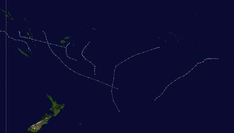 | ||
The 1999–2000 South Pacific tropical cyclone season was an event in the annual cycle of tropical cyclone formation and ran from November 1, 1999, to April 30, 2000, in the South Pacific.
Contents
- Severe Tropical Cyclone Iris
- Severe Tropical Cyclone Jo
- Severe Tropical Cyclone Kim
- Tropical Cyclone Leo
- Severe Tropical Cyclone Mona
- Tropical Cyclone Neil
- Other systems
- References
It should also be noted that the regional tropical cyclone operational plan defines a "tropical cyclone year" separately from a "tropical cyclone season", with the "tropical cyclone year" for this season lasting from July 1, 1999, to June 30, 2000.
All of the six named storms affected land in some way, but no major damage was reported from any of the storms.
Severe Tropical Cyclone Iris
A disturbance was identified on 3 January at 0600 (UTC) near Espiritu Santo in Vanuatu. The storm was difficult to locate the general centre for the next couple of days, but on 6 January, it became more organised, while displaying midget characteristics. On 7 January at 2100 (UTC), it was named Tropical Cyclone Iris, located 330 km (205 mi) northwest of Port Vila, moving southeast. In Vila, 110 km (70 mi) away from Iris's centre, recorded winds of only up to 20 knots (37 km/h), explaining the very small size of the cyclone. Iris intensified with 10-min winds increasing to 60 knots (110 km/h) on 8 January at 1200 (UTC). JTWC's estimated 1-min winds was 65 knots (120 km/h). There were some indications that Iris could be far more intense than what the warning centres estimated, mainly due to its small size. Iris accelerated eastward, leaving Vanuatu. On 9 January, Iris began its weakening trend, while moving closer to Fiji. Iris was downgraded to a depression on 10 January, just 48 hours after it had reached its peak intensity. The final warning placed the centre on the Dateline 150 nmi (280 km) southeast of Fiji.
Fresh to strong winds and very rough seas were experienced over the western and southern parts of Fiji. Overall damage was minimal. Cyclone Iris was most notable for its rapid strengthening in its early stages, followed by its rapid decay.
Severe Tropical Cyclone Jo
A disturbance was first identified over northern parts of Vanuatu on 19 January. It developed slowly, but deepened quickly on 22 January, and advisories were issued on the system on 23 January. It moved southward and was upgraded to Tropical Cyclone Jo on 24 January at 0300 (UTC). Jo moved to the south-east and attained storm force winds 15 hours after being named. The cyclone reached its peak intensity on 26 January at 0000 (UTC) located 650 km (400 mi) south of Nadi, with 10-min average winds of 60 knots (110 km/h). JTWC's peak 1-min average winds were 65 knots (120 km/h). Jo moved further to the south-east, and moved close enough to affect Fiji. Gusts to 50 knots (93 km/h) were recorded on Viti Levu on Fiji, even though Jo was about 445 km (275 mi) away from the Fiji. Flash flooding was reported, but there was no major river flooding. Cyclone Jo was declared extratropical on 28 January at 0600 (UTC) when located more than 1,000 nmi (1,900 km) east of North Island in New Zealand.
Severe Tropical Cyclone Kim
During February 22, a cold core low developed into a tropical depression, about 110 km (70 mi) to the east-southeast of Rikitea in French Polynesia. It initially developed little but late on 24 February, the depression developed rapidly, and the storm reached tropical storm strength at 1800 (UTC), named Tropical Cyclone Kim. It was located about 75 km (45 mi) west of Rikitea or about 125 km (75 mi) southeast of Mururoa. Cyclone Kim reached hurricane strength on 25 February, only 18 hours after being named, while moving to the south-west. The storm reached its peak intensity of 80 knots (150 km/h) on 26 February at 1200 (UTC), located more than 1295 km (805 mi) east of Tahiti. Minimum pressure at this time was 955 mbar. The estimated 1-min average winds from NPMOC was 100 knots (190 km/h). Kim gradually weakened over cooler waters, still moving to the south-west. Cyclone Kim became extratropical south of Tahiti on February 29 at 0600 (UTC).
Damage from Kim was minimal from Rikitea, since it was only a depression at the time. The island recorded 10-min average winds of 27 knots (50 km/h), with a peak gust of 52 knots (96 km/h) and a minimum pressure of 996 mbar. As a hurricane, the island of Rapa Iti recorded a gust of 74 knots (137 km/h), when Kim was 150 km (90 mi) away from the island. A pressure of 995.8 mbar was recorded. Overall, damage in French Polynesia was minor.
Tropical Cyclone Leo
On March 4, RSMC Nadi reported that Tropical Disturbance 14F had developed about 95 km (60 mi) to the west-northwest of French Polynesia under a tropical upper tropospheric trough
Severe Tropical Cyclone Mona
As Leo was developing, a new disturbance formed south of Apia in Western Samoa. The first gale warning was issued on 7 March as it moved closer to northern Tonga. Wind warnings were issued for some islands in Tonga including Vavau, Haapai and Tongatapu. The storm rapidly developed on 8 March at 0600 UTC, and was named Tropical Cyclone Mona six hours later, while located 75 km (45 mi) west of Haapai and moving slowly southward. A storm warning was put for the whole Tongatapu Group on the 8th. An eye developed on 9 March, and Mona was upgraded to hurricane intensity at 0600 UTC, located 55 km (35 mi) west of Tongatapu. Mona moved south-southeastward and accelerated. It reached an intensity of 75 knots (139 km/h) on 10 March, 370 km (230 mi) southeast of Tongatapu. NPMOC's 1-min winds were estimated at 80 knots (150 km/h). Minimum pressure of Mona was 965 mbar. It began to weaken rapidly, as it sped off southwards, and became extratropical on 11 March at 1200 UTC.
In the Vavau and Haapai groups, there was damage to crops, particularly to banana and coconut plantations. There was moderate damage to houses and school buildings in Tongatapu. The unofficial damage assessment, according to the Tongan National Disaster Management Office, totalled Tongan $6 million. A police patrol boat sank off Eua Island in the Tongatapu group.
Tropical Cyclone Neil
On April 12, RSMC Nadi started monitoring a tropical disturbance, that had developed within a trough of low pressure to the northeast of Fiji. During the next day the system moved southwestwards towards Fiji and developed into a tropical depression, as convention around the center increasing. At 1700 UTC, it was named Tropical Cyclone Neil, located 150 km (90 mi) southeast of Kadavu. It moved slowly southward, but on 16 April at 1200 UTC, it was downgraded to a tropical depression.
Damage from Neil was minimal. Kadavu and Ono-i-Lau in Fiji reported gales from Neil, while torrential rain was experienced over some parts of Fiji. There was one fatality due to drowning, but not directly associated with the cyclone.
Other systems
On September 5, a tropical depression had developed in conjunction with a weak tropical wave about 600 km (375 mi) to the south-southeast of Port Vila in Vanuatu. During that day the depression moved slowly towards the southeast, while weakening due to the influence of north-westerly windshear, before the final advisory was issued during September 6. Tropical Disturbance 01F and 02F then developed towards the end of November, but remained weak and did not significantly develop. On December 1, Tropical Depression 03F developed near the Vanuatuan islands, over the next few days the depression remained near stationary before it was last noted on December 3. Tropical Depression 04F developed near New Caledonia on December 5, over the next few days it moved quickly towards the east, before weakening during December 7, while located near the Tongan Islands.
On April 10, RSMC Nadi reported that Tropical Disturbance 18F had developed from an upper level low, the system subsequently moved south-eastwards but was never classified as a tropical depression.
Tropical Disturbance 23F developed between Fiji and Vanuatu during May 6, and was briefly referred to as a tropical depression by RSMC Nadi but it develop further as it was sheared. Tropical Disturbance 24F subsequently developed near the Solomon Island of Rennell during May 20, and moved westwards into the Australian region over the next day.