
Type Tornado outbreak Tornadoes confirmed 29 Duration of tornado outbreak 21 hours, 45 minutes Damage 140 million USD | Duration March 27, 1994 Max rating Start date March 27, 1994 | |
 | ||
Similar 1965 Palm Sunday tornado o, Enigma tornado outbreak, 1932 Deep South tornado o, December 2000 Tuscaloo, February–March 2007 tornado o | ||
Weather history 1994 palm sunday tornado outbreak
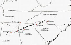
The 1994 Palm Sunday tornado outbreak was the third notable US tornado outbreak to occur on Palm Sunday and the second to take place in the southeastern United States on that day. 40 people were killed and 491 were injured in the outbreak. In all, 29 tornadoes struck Texas, Alabama, Georgia, South Carolina, and North Carolina, causing $140 million in damage. The deadliest tornado of the outbreak was rated F4 on the Fujita scale; it was the deadliest tornado in the U.S. in 1994. The storm devastated the Goshen United Methodist Church near Piedmont, Alabama, collapsing the roof on the congregation during a Palm Sunday service and killing 20 people inside, including the Rev. Kelly Clem's 4-year-old daughter Hannah. Two other houses of worship were also destroyed mid-service. The supercell that formed this tornado tracked for 200 miles (322 km) to South Carolina.
Contents
- Weather history 1994 palm sunday tornado outbreak
- Synoptic Setup and Timeline
- RomeCantonJasper Georgia
- Cave SpringLindale Georgia
- Effects on National Safety
- Further information
- References
Synoptic Setup and Timeline
The SPC started forecasting the outbreak on March 26, highlighting the risk of severe thunderstorms over the area that would eventually be impacted, issuing a "severe" forecast for most of the southern states, and some states in the Mid-Atlantic, forecasting "the potential for supercell storms, along with the possibility of tornadoes."
By the morning of March 27, it was apparent that a very strong and potent airmass had set up over the Gulf states, with the SPC issuing a moderate risk for most of Alabama, the southern half of Mississippi, and most of Louisiana in their morning outlook.
The 6 AM CST (1200 UTC) 500 MB analysis showed a strong southwest flow of near 80 knots over the southern U.S., while at the 850 MB level, there existed winds of near 50 knots coming out of the state of Louisiana. At the surface, temperatures in Alabama, Mississippi, and Georgia were in the low 70's Fahrenheit, with dewpoints were in the upper 60's to low 70's. CAPE values at Centreville, Alabama were nearing 1,200 j/kg with no cap to speak of. A surface front left by rain during the previous evening was situated over northern parts of Alabama, Mississippi, and Georgia.
By 9 AM CST (1500 UTC), thunderstorms and severe weather were not only occurring along the boundary setup by the rain from the previous evening in the northern portions of Alabama and Mississippi, but further to the south as well. At 9:18 AM CST (1518 UTC), the SPC issued a tornado watch for eastern Mississippi and northern Alabama. The storms then rapidly intensified, with tornado warnings being issued by the Birmingham and Huntsville NWS offices before 11 AM local time. Both the deadly F4 that struck the Goshen United Methodist Church in Cherokee County and the Marshall County F2 formed at about this time. The SPC also issued a PDS tornado watch for all of northern Georgia by 12 PM EST (1700 UTC), with the wording stating, "This is a particularly dangerous situation with the possibility of very damaging tornadoes. Also, large hail, dangerous lightning and damaging thunderstorm winds can be expected." Severe storms and tornadoes tracked into the northern Georgia region by 12:42 EST, and tornadoes continued to track across northern Georgia during the afternoon.
During the early-mid afternoon, analysis showed a very unstable airmass over the southern U.S., with CAPE values near 2,500 j/kg and SRH values of near 250 m2/s2 at Jackson, Mississippi. The 1800 UTC Centreville, Alabama sounding showed similar conditions, with CAPE over 2,500 j/kg and SRH values of over 500 m2/s2. This resulted in an EHI value of 8.49, which is strongly supportive of tornadic thunderstorms. Based on these soundings, the SPC issued a high risk for their 1930 UTC outlook, noting a rapidly destabilized atmosphere and winds being much stronger than what was originally forecasted.
Noting the presence of a shortwave trough that was tracking into Mississippi and Louisiana as well as rapidly falling pressures in advance of a frontal boundary, the SPC issued a tornado watch for eastern Louisiana and central Mississippi, however, there were no reported tornadoes in this region on March 27th. The SPC, seeing that storms were tracking into the Carolinas, issued a tornado watch for portions of the western and central Carolinas, as well as the portion of northeast Georgia not already included in the prior tornado watch. Tornadoes continued to track along this area from the mid-late afternoon, with an F3 striking parts of northeast Georgia and the upstate of South Carolina, injuring 12, and another tornado along the border region of North Carolina and South Carolina injuring 13.
In Alabama, tornadoes continued in the central part of the state during the mid-late afternoon. An F1 struck parts of Tuscaloosa County just after 4 PM. Funnel clouds were seen in Hueytown as a storm went over Jefferson County at around 4:30 PM local time. An F2 tornado was produced in Shelby County at 5:30 CST, damaging a high school and a residential neighborhood before destroying two moblie home parks.
During the cleanup from the F4 that struck Cherokee County, emergency responders had to take cover as another funnel cloud was spotted just before 6 PM CST. The storms also produced hail up to 3 inches in diameter and winds around 60 miles per hour. The storm system also left behind extensive flooding in Winston and Walker Counties, with $150,000 worth of damage done to roads and bridges in Walker County.
The final tornado of the outbreak was reported just before midnight in Greenville County in South Carolina. The National Weather Service offices in Birmingham, Atlanta, and Athens did not stop issuing warnings until late at night on the 27th or early in the morning on the 28th, issuing 75 tornado warnings and 182 severe weather products overall.
Overall, the outbreak of March 27, 1994 was not as synoptically evident as some of the past outbreaks that have occurred, as there was no deep surface low or trough present for forcing in the area where the storms occurred, and many the ingredients necessary that were the cause of this outbreak were not able to be forecasted until the morning of the event.
Rome–Canton–Jasper, Georgia
The second violent tornado of the outbreak developed in a rural area of Floyd County, Georgia, about 9 miles (14 km) southeast of Rome, at 1:14 p.m. EST. Upon touching down, the .125-mile (0.201 km) wide tornado uprooted large pines and oaks while causing F0 damage to five or six homes of "mixed brick and wood construction." The tornado then moved northeast as it snapped trees before intensifying to F1 strength about 10 miles (16 km) west of Cartersville. During this, the tornado initially shrunk to .06 miles (0.097 km) wide, but then widened again to .125 miles (0.201 km) as it passed through Cassville, with F1 damage primarily to the roofs of 10–15 homes. The tornado blew down 20 large trees and damaged power lines in Cassville.
Thereafter, the tornado increased greatly in size and intensity as it passed between White and Rydal, with the first and only F4 damage occurring in a rural area 15 miles (24 km) northwest of Canton. There, the 0.38-mile (0.61 km) wide tornado leveled "five two-story brick and wood homes" to the ground in the Indian Springs subdivision. The tornado also severely damaged eight to 10 other homes and slightly damaged 12–15. Overall, the tornado was most destructive at Indian Springs and soon weakened as it continued northeast through wooded lands; however, its path briefly widened. It killed two people in a trailer along Georgia State Route 140 in Bartow County and snapped 80-to-90-foot (24 to 27 m) tall pine trees nearby. Though the 1-mile (1.6 km) wide tornado impacted forested areas, it still caused major damage to 10 mobile homes and six permanent homes, as well as damage to four unspecified vehicles.
Henceforth, the tornado continued to weaken to F2 intensity and contracted to .75 miles (1.21 km) wide as it passed into Pickens County, severely damaging 10–15 chicken coops along with 20–25 homes of brick and wood construction. It killed one more person in a trailer before lifting from the ground about 6 miles (9.7 km) east-southeast of Jasper. Ultimately, it caused almost $7 million (1994 USD) in losses to properties and businesses in Bartow County alone, with another $1.5 million in losses in adjourning Pickens County. The tornado killed three people and over 500,000 chickens along its track and leveled "thousands" of trees, with over $10 million in losses to agricultural interests.
Cave Spring/Lindale, Georgia
The sixth and final F3–F4 tornado to hit Georgia on March 27 touched down 8 miles (13 km) northwest of Cedartown at about 7:00 p.m. EST. Though mainly impacting rural areas at first, it badly damaged four wood homes and blew down many trees with resultant F1 damage. The tornado appeared reddish to eyewitnesses as it passed through rugged terrain. As it crossed near Georgia State Route 100, the tornado produced major roof damage to a few homes and destroyed a pair of chicken coops. Widening to 0.5 miles (0.80 km) wide, the tornado acquired a multiple vortex structure as residents observed two or three funnels rotating around the main vortex. In southern Floyd County, about 2 miles (3.2 km) east of Cave Spring, the multiple-vortex tornado snapped trees in half and badly damaged five double-wide mobile homes along with three or four frail wood homes.
Afterward, the tornado strengthened to F2 intensity, causing more severe damage to wood homes, but soon contracted in size to .25 miles (0.40 km) wide and weakened into an F1 tornado. However, as it neared to within 2.5 miles (4.0 km) southwest of Lindale, it widened yet again and rapidly strengthened into an F3 tornado as it passed through Leawood Estates. There, it reportedly leveled "fifteen mixed single and two story mixed brick and wood homes of poor construction," along with some homes that were being built. The tornado caused 30 injuries, including one of a man who was thrown 1,000 yards (0.57 mi) into the street across from his home. Residents reported continuous lightning preceding and during the passage of the tornado and were alerted by their dogs barking. Some residents also reported a smaller tornado south of the primary one.
After hitting Leawood Estates at maximum intensity, the tornado weakened back into an F2 tornado and shrunk to .25 miles (0.40 km) wide as it passed 6 miles (9.7 km) south of Rome. There, it badly damaged three poorly built wood homes, destroyed four mobile homes, and uprooted large trees. Farther along, it decreased in size to just .125 miles (0.201 km) wide but caused significant damage to 15–20 homes of brick and wood construction. As it passed 7.2 miles (11.6 km) southeast of Rome, the tornado degenerated into an F0 tornado over wooded farmland while causing major roof damage to a few homes before dissipating. According to the National Weather Service, the tornado destroyed 55–60 homes and did at least some damage to 140–150 others, with total losses reaching $6,750,000.
Effects on National Safety
The deaths at Goshen United Methodist Church brought to light the deficiencies in the NOAA Weather Radio network across the United States and the lack of NOAA Weather Radio use in many public spaces. Budget cuts in the 1970s had forced the National Weather Service to cut back on the expansion of new broadcast stations. Most urban and suburban areas in the country had sufficient coverage, but many rural areas had no coverage at all. After a visit to the Goshen site, then Vice President Al Gore pushed for further funding and expansion of the NOAA Weather Radio system, especially in rural areas. This was accomplished through an expansion of private-public partnerships, primarily by the National Weather Service leasing or using donated tower space from entities such as TV stations, public utilities, and state government agencies. Gore, also, pushed for facilities such as schools, hospitals, churches, and nursing homes to have weather radios on hand.