
Type Tornado outbreak Tornadoes confirmed 60+ estimated Duration of tornado outbreak 15 hours | Duration February 19–20, 1884 Max rating Start date February 19, 1884 | |
 | ||
Damage >$3–4 million (1884 USD) Similar 1932 Deep South tornado o, January 2008 tornado o, February–March 2007 tornado o, Late‑November 2005 tornado o, 1984 Carolinas tornado o | ||
The 1884 Enigma outbreak is thought to be among the largest and most widespread tornado outbreaks in American history, striking on February 19–20, 1884.
Contents
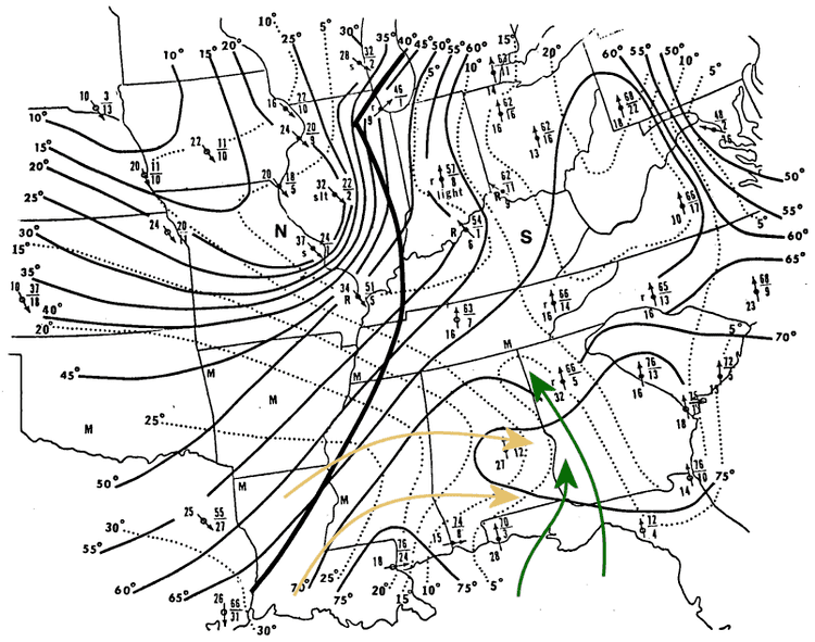
As the precise number of tornadoes as well as fatalities incurred during the outbreak are unknown, the nickname "Enigma outbreak" has come to be associated with the storm. Nonetheless, an inspection of newspaper reports and governmental studies published in the aftermath reveals tornadoes (or more likely — long-track tornado families) striking Alabama, Georgia, Illinois, Indiana, Kentucky, Mississippi, North Carolina, South Carolina, Tennessee and Virginia, with an estimation of at least 50 tornadoes. Some events counted as tornadoes in initial studies such as those by John Park Finley were downbursts, especially in northern and northeastern portions of the outbreak.
The majority of reported tornado activity was seen across Alabama, Georgia, South Carolina and North Carolina, which were all struck severely by multiple waves of tornado families. In the Southeast, the outbreak began during the late morning in Mississippi, preceded by severe thunderstorms in Louisiana. Shortly thereafter, the outbreak widened and intensified, progressing from Alabama to Virginia between noon and midnight.
Elsewhere, wind damage, flash flood (with homes swept away by water in Louisville, Kentucky, New Albany, Indiana, and Jeffersonville, Indiana and other towns along the Ohio River) and derecho-like effects in the Ohio Valley were also reported in published accounts of the outbreak. Blizzard conditions occurred in the eastern Midwest.
According to an article appearing in the Statesville (NC) Landmark three days later, the damage tally in Georgia alone was estimated to be $1 million, in 1884 dollars. Tabulations from 1884 estimate a total of $3–4 million in tornado damage (with an unknown amount of flood and other damage), with 10,000 structures destroyed.
Confirmed tornadoes
Polkton / Ansonville tornado
This was the first of a number of destructive North Carolina storms. Detailed coverage in a newspaper in Wadesboro, NC provides an unusually (by 19th century standards) precise survey of the movement and damage produced by three of those storms in the southern piedmont region of NC.
This storm first formed in southeastern Union County, from a supercell that had produced significant damage in South Carolina earlier. Most of the path of this storm was in rural areas, with injuries and major damage along Beaverdam Creek, south of Marshville in Union County, and along Brown Creek in Anson County, northeast of Polkton.
Significant damage also occurred in and around the towns of Polkton and Ansonville, where structures in both towns were widely damaged, with homes and farm buildings destroyed south of Ansonville. A total of four people were killed. Eyewitnesses in Polkton noted that the storm "crossed the railroad about a mile east of Polkton last night prostrating everything in its course. Could see the storm from Polkton by lightning, looked like a cloud of dense smoke and sounded like thunder. Hail stones measuring 2½ inches long, 1½ inches wide and one inch thick fell."
Homes also destroyed near Pekin, in Montgomery County.
Pioneer Mills tornado
This storm was preceded and followed by a wide area of downburst damage - with scattered areas of damage to farms and small structures reported across a wide area of southern Cabarrus County, eastern Mecklenburg County (NE of Mint Hill) and the Goose Creek area of northwestern Union County.
The first tornado-specific damage occurred in the Pioneer Mills community between Harrisburg and Midland in Cabarrus County, where a mill was destroyed and estimated F2 damage was inflicted upon several residences. Storm passed within two miles (3 km) of Albemarle; little damage was recorded elsewhere in Stanly County. Several poorly constructed buildings were destroyed along the Uwharrie River in Montgomery County, and damage to farms was widespread in the county. One person was killed. Downburst damage continued to SW of Asheboro.
Rockingham tornado
Spawned late in the outbreak, the storm which swept from Anson to Harnett Counties in North Carolina passed through the Rockingham area, and became the deadliest tornado in recorded North Carolina history. This storm first touched down east of the town of McFarlan, in southeastern Anson County. The storm produced little damage in Anson County.
Tracking to the northeast, it crossed the Pee Dee River into Richmond County, and produced sporadic damage until just southeast of Rockingham. Extreme damage to pine forests was first noted just south of town. Strengthening considerably, the storm swept through the southeast edge of Rockingham, where large homes were destroyed to their foundations, and large hardwood trees were snapped at ground level. The Philadelphia Church community (presently on US Highway 1, 3 miles northeast of downtown Rockingham) was devastated, with most of the poorly constructed dwellings in the community completely destroyed. The storm had widened to nearly 1 mile in width at this point.
The storm then tracked through what is now the town of Hoffman, before entering Moore County. Severe damage was again seen in the community of Manly (presently at the northeast corner of the city of Southern Pines). The storm then curved slightly to the east, dissipating into a wide area of downburst damage near the community of Johnsonville. A total of 23 people were killed.
An unusually detailed accounting of the storm's passage through Richmond County, NC was provided two days later: a local resident undertook an informal, but detailed survey of the damage produced by the storm, and this account was published in an Anson County (NC) newspaper. This accounting establishes a steady SW-to-NE movement through the county, with a number of buildings - sharecropper cabins, large homes, and a mill - swept away along the path. As the storm passed 1 mile (1.6 km) SE of downtown Rockingham, it may have peaked in intensity; it was noted that all structures along a 5 miles (8.0 km) segment of the path (beginning at this point) were destroyed. The surveyor noted a path width of 0.25 miles (0.40 km) to 0.5 miles (0.80 km), with the most extreme damage (and most deaths) in the Philadelphia Church community. The surveyor noted that:
Trees were taken up by the roots and hurled with fearful rapidity through the air and those not uprooted had all the bark taken off. The scene after the storm, particularly the position of the prostrate trees, indicated a convergence toward the center, as if a vacuum was created there and the wind rushed in from either side to fill it.
A second, detailed survey of the path was made 10 days later by J.A. Holmes; his findings were published in the Elisha Mitchell Scientific Society journal for 1884.
Eyewitnesses reported large hail and intense lightning displays preceding the storm. Moving to the northeast, away from Rockingham, the storm also produced severe damage in the Keyser and Manly communities, along the southeast edge of Moore County.