
Formed August 23, 1949 Fatalities 2 direct Highest winds 209 km/h | Dissipated August 31, 1949 Damage $52 million (1949 USD) | |
 | ||
Lowest pressure 954 mbar (hPa); 28.17 inHg Areas affected Leeward Islands, Puerto Rico, Hispaniola, Turks and Caicos Islands, Cuba, Bahamas, Eastern United States, Eastern Canada Date 23 August 1949 – 31 August 1949 Affected areas Puerto Rico, Hispaniola, Eastern United States Similar 1945 Homestead hurricane, Hurricane Fox, Hurricane Gracie, Hurricane Inez, 1947 Fort Lauderdale hurricane | ||
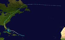
The 1949 Florida hurricane was the second recorded storm and the strongest and most intense tropical cyclone of the 1949 Atlantic hurricane season. It was the most intense tropical cyclone to affect the United States during the season, with a minimum central pressure of 954 mbar (28.18 inHg) at landfall. The cyclone originated from an easterly wave near the Leeward Islands, and it rapidly intensified to a hurricane near the Bahamas. It strengthened to a major hurricane northwest of Nassau, Bahamas, and it struck West Palm Beach, Florida as a Category 4 hurricane with maximum sustained winds near 130 mph (210 km/h) and peak gusts near 160 mph (260 km/h) above the surface. It turned north over the Florida peninsula, and it transitioned to an extratropical low pressure area over New England. The tropical cyclone inflicted $52,000,000 (1949 USD) in damage, most of which was incurred in the state of Florida. It was the costliest storm of the season.
Contents
Meteorological history
On August 23, a moderate tropical storm developed 200 miles (323 km) east of Sint Maarten. Operationally, the system was treated as an easterly wave until it moved through the Bahamas. It is believed that the system originated near the Cape Verde islands. On August 24, the tropical storm passed north of the Leeward Islands and San Juan, Puerto Rico, and then strengthened to a minimal hurricane with 75 mph (120 km/h) winds on August 25. Subsequently, it strengthened rapidly, and the cyclone was noted as "well developed" when it passed near Nassau with 115 mph (185 km/h) winds on the morning of August 26. At the time, it was the equivalent of a Category 3 hurricane on the Saffir-Simpson Hurricane Scale. The storm strengthened further over the Gulf Stream, and it moved ashore over the city of West Palm Beach as a strong Category 4 hurricane around 7:20 p.m. EDT. The city's airport reported calm conditions from 7:20–7:40 p.m., and the minimum central pressure of 954 mbar (28.18 inHg) was measured at the site. Peak gusts were recorded at 125 mph (205 km/h) before the anemometer blew away. A maximum sustained wind of 153 mph (246 km/h) was reported from the Jupiter Inlet Light station prior to the loss of the anemometer; although conditions were slightly more severe after the reading, reliable estimates are unavailable. The Atlantic hurricane database lists the cyclone as a strong Category 4 hurricane at landfall. The wind reading is the basis for the Category 4 designation in the Atlantic hurricane database, although a reduction from the anemometer's elevated location lends credence to the concept of a weaker system. Originally, the system was designated as a Category 3 hurricane in the state of Florida, based on the minimum central pressure reading of 954 mbar (28.18 inHg); this pressure corresponds to the original classification of a Category 3 hurricane on the Saffir-Simpson Hurricane Scale. However, modern analysis applies Saffir-Simpson rankings based on maximum sustained wind speeds. The 1949 Florida hurricane will be eventually reanalyzed by the Atlantic hurricane reanalysis project, which may find a weaker hurricane in Florida. The central pressure of 954 mbar (28.18 inHg) is unusually high for a strong Category 4 hurricane; the reanalysis project has discovered that hurricanes erroneously featured stronger winds than the typical pressure/wind relationship in the 1940s–1960s, unlike subsequent hurricanes in the 1970s–1980s. The evidence suggests wind speeds may have been overestimated for hurricanes in the 1940s–1960s.
Inland, the hurricane moved over the northern portion of Lake Okeechobee, following a similar path as the 1928 Okeechobee hurricane. On August 27, the hurricane recurved over the Florida peninsula, and then weakened to a Category 1 hurricane northeast of Tampa. The system diminished to a tropical storm near Cedar Key, and it entered southern Georgia during the morning of August 28. The system passed over the Carolinas as a weak tropical storm, and it was operationally noted as a "weak disturbance" at the time. The cyclone passed through the Mid-Atlantic states and New England on August 29; it became extratropical over New Hampshire. On August 31, the extratropical low was last detected over the western North Atlantic Ocean.
Preparations
On August 25, the northern Bahamas were advised to initiate hurricane precautions, and a hurricane warning was issued for the islands. South Floridians were encouraged to closely monitor the progress of the storm. On August 26, hurricane warnings were released from Miami to Vero Beach; officials decided to cancel proposed evacuations of the Lake Okeechobee region, as the presence of the Herbert Hoover Dike was expected to prevent flooding.
Impact
In the Bahamas, the cyclone produced 120 mph (195 km/h) wind gusts on Bimini. Damages in the Bahamas are unknown.
In Florida, the hurricane produced hurricane-force gusts from Miami Beach to Saint Augustine. The majority of the state experienced sustained winds of at least 50 mph (85 km/h). The strongest winds of 100-126 mph (161-203 km/h) were observed in the Lake Okeechobee region, while unofficial wind gusts reached 160 mph (260 km/h) at Stuart. Additionally, Vero Beach reported sustained winds of 97 mph (156 km/h) and peak gusts of 110 mph (177 km/h). The minimum central pressure near Lake Okeechobee was 956 mbar (28.24 inHg) at Canal Point. Palm Beach, Jupiter, and Stuart experienced the most severe damage from the storm in south Florida; hundreds of homes, apartment buildings, stores, and warehouse buildings lost roofs and windows. Interior furnishings were blown through broken glass into the streets. Overall, the storm caused two deaths and $52 million in damage, mostly in Florida.
Trees and power lines were knocked down in Miami. Five homes were destroyed in Delray Beach. The "negro section" of Boynton Beach suffered $10,000 in damage. Tides lashed the coast, with the worst impact between Lake Worth and Palm Beach. Much of the island of Palm Beach was covered with power lines, trees, broken glass, sand, and other debris. Between Joseph E. Widener's mansion in Palm Beach and the Lake Worth casino, several washouts were reported. Along State Road 704 (Royal Palm Way), many royal palm trees were toppled. At the Society of the Four Arts, several trees were uprooted and the library garden was ruined. The radio antenna at the town hall collapsed, damaging the roof, police and firefighters barracks, the door to the fire station, and a car. Palm Beach suffered approximately $2.6 million in damage. In Lake Worth, a total of about 400 people stayed at six shelters in the area during the storm. Between 300 and 400 homes were impacted by the storm, with most of the effects limited to broken roofs, shattered windows, and water damage. One home was completely demolished. This does not include the number of homes deroofed in the "negro quarters". Additionally, a trailer was overturned and "rolled over and over like a rubber ball". Many plate-glass windows broke in the business district, while a filling station on State Road 802 was destroyed.
In West Palm Beach, cars were overturned in the interior of a dealership as winds shattered windows.
Tides reached 12 feet (144 in) above normal at Belle Glade and Clewiston, but the Herbert Hoover Dike remained intact, protecting the area from severe flooding. Minimal erosion occurred in some locales.
Water entered many homes in Palm Beach and Martin counties. Snakes and mosquitoes infested many residences. Precipitation totals of 8.18, 7.10, and 9.51 inches (242 mm) were measured at Belle Glade, Okeechobee, and St. Lucie Lock, respectively. Radio towers were toppled in Lake Worth and Belle Glade.
Severe damage was received by 40 percent of Stuart's residences and commercial structures, and 90 percent required repairs. A church, baseball park, and ice company was destroyed in the area's black neighborhoods. Many flimsy buildings were destroyed in the neighborhoods. Three portions of the Jensen causeway near Sewall's Point were ripped away. A hangar and beacon was destroyed at the local airport in Martin County. 500 people were homeless in Stuart. A water mark of 8.5 feet (102 in) was recorded on the St. Lucie River near Stuart.
The cyclone inflicted heavy citrus losses, and one-third of the trees were uprooted in many groves. Agricultural losses reached $20 million (1949 USD), including 14 million boxes of fruit. Wind gusts of 75 mph (120 km/h) affected Clermont, and numerous central Florida communities reported severe damage from the winds. The observation station at Archbold Biological Station reported peak wind gusts of 110 mph (175 km/h); the town of Sebring reported 125 mph (205 km/h) gusts, which caused damage to trees and severe structural damage to buildings. Estimations of property damage reached $100,000 (1949 USD) in the town, and local citrus groves estimated losses near $2,000,000 (1949 USD). Buildings received considerable damage in the Lake Placid area, and telegraph, telephone, rail, and bus services were disrupted. Flooding affected Georgia and the Carolinas, although the rains alleviated drought conditions in Maryland, Pennsylvania, New York, and New England. Charleston, South Carolina reported a wind gust of 80 mph (129 km/h), and power lines were damaged. In Maryland, damage was minimal, although trees were prostrated and electrical services were down. Two people were killed in Florida, but advance warnings prevented a higher death toll.