
First system formed June 21, 1867 Name Nine Hurricanes 6 | Last system dissipated October 31, 1867 Total storms 9 Major hurricanes(Cat. 3+) 1 | |
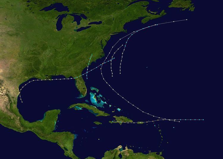 | ||
The 1867 Atlantic hurricane season lasted from mid-summer to late-fall. A total of nine known tropical systems developed during the season, with the earliest forming on June 21, and the last dissipating on October 31. On two occasions during the season, two tropical cyclones simultaneously existed with one another; the first time on August 2, and the second on October 9. Records show that 1867 featured two tropical storms, six hurricanes and one major hurricane (Category 3+). However, in the absence of modern satellite and other remote-sensing technologies, only storms that affected populated land areas or encountered ships at sea were recorded, so the actual total could be higher. An undercount bias of zero to six tropical cyclones per year between 1851 and 1885 and zero to four per year between 1886 and 1910 has been estimated. Of the known 1867 cyclones Hurricanes Three, Four and Six plus Tropical Cyclones Five and Eight were first documented in 1995 by Jose Fernandez-Partagas and Henry Diaz. Hurricane One was first identified in 2003 by Cary Mock.
Contents
- Hurricane One
- Hurricane Two
- Hurricane Three
- Hurricane Four
- Tropical Storm Five
- Hurricane Six
- Hurricane Seven
- Tropical Storm Eight
- Hurricane Nine
- References
The strongest storm of the season was Hurricane Nine, or the San Narciso Hurricane. It developed in the Central Atlantic, and moved west to impact the Leeward Islands and Greater Antilles. The storm system was a major Category 3 hurricane on the Saffir-Simpson hurricane scale, meaning the hurricane had maximum sustained winds of 111–130 mph (178–209 km/h). This was the costliest, and deadliest, storm of the season, causing at least $1 million (1867 USD) in damage, and at least 800 deaths across the Caribbean Sea.
Hurricane One
On the morning of June 21, a tropical storm formed approximately 65 mi (105 km) east northeast of Daytona Beach, Florida. Initially below hurricane strength with a maximum sustained wind speed of 60 mph (97 km/h), the tropical storm moved almost due north, while strengthening steadily. By the early hours of June 22, the system had intensified into a Category 1 hurricane, while moving slowly east northeastward. Early on June 23 the hurricane made landfall east of the city of Charleston, South Carolina, with peak winds of 80 mph (130 km/h). In Charleston a number of roofs were blown away, trees were uprooted and wharves damaged. Outside the city there was considerable damage to crops due to heavy rainfall. Weakening steadily, the system's last known location was near Raleigh, North Carolina, on June 23.
Hurricane Two
During the last days of July, a hurricane was reported about 375 mi (600 km) east-northeast of Dominica. Tracking generally northwestward, the storm changed little in intensity until located to the north of Grand Turk. From there, it proceeded northwestward, and intensified to near Category 1 hurricane status. As it moved to the southwest of Wilmington, North Carolina, the storm attained its peak intensity of 100 mph (160 km/h); shortly thereafter, it commenced re-curving to the north. Resuming a more northeasterly track, the cyclone began to go undergo a weakening trend, and once again became a Category 1 storm. Further weakening occurred while the hurricane was located to the west of Sable Island. The Town records of Marblehead, MA, record the deaths of 10 men and a boy on August 2, 1867, when their fishing schooner was "lost in a gale" off Sable Island. The storm was last reported to the southeast of Cape Race on the island of Newfoundland. It caused two deaths off the United States East Coast before dissipating the same day (August 3). As the storm passed by the Mid-Atlantic, a ship encountered the storm in the pre-dawn hours of August 2 (2:00 am), about 140 mi (230 km) east of Norfolk, Virginia; a pressure reading of 28.6 inHg (970 mbar) was recorded two hours later. Around 4:00 am the same day, the brig Chanticleer, located near the lower Delaware coast, recorded a strong gust of wind. A little after dawn, gusts over hurricane strength were being recorded at the same location. The Oak Ridge passed directly through the eye of the hurricane, reporting winds first from the east southeast, turning calm for short while, before a wind from the west blew. Another ship located just south of Montauk point reported hurricane-force winds for three hours, and the barometer fell 14 mbar (0.41 inHg) in an hour and a half.
Hurricane Three
Early on August 2, a hurricane developed over the central Caribbean Sea. The storm reached an estimated peak intensity of 100 mph (160 km/h), making it a Category 2 hurricane. The report of the hurricane was based on observations from the ship Suwanee, with no other reports available.
Hurricane Four
Late on August 31, a Category 1 hurricane with maximum sustained winds of 80 mph (130 km/h) was reported over the Central Atlantic. Moving generally north to north-northeast, the storm gained no intensity over the next day or so as it passed between the United States East Coast and Bermuda. Late on September 2, the storm retained tropical storm status as it paralleled the coast of Washington, D.C. Retracing to the east at an increasing forward speed, the storm system held its intensity of 70 mph (110 km/h) for the rest of its existence. Observations from the ship Helen R. Cooper confirm that this storm was in fact a hurricane.
Tropical Storm Five
Early on September 8, the schooner Matilda encountered a tropical cyclone two hundred miles to the east of the Leeward Islands. The storm's recorded wind speeds reached no more than 60 mph (97 km/h), and there were no further reports of it on subsequent days.
Hurricane Six
Late on September 29, a Category 1 hurricane formed several hundred miles north of the Bahamas. Tracking to the north, the storm system gained very little strength while passing several hundred miles southwest of Savannah, Georgia. It reportedly attained Category 2 hurricane status while located approximately 100 mi (160 km) to the east of Cape Hatteras, North Carolina, with winds peaking at 100 mph (160 km/h). Spinning to the north-northeast, the hurricane eventually entered a weakening phase, and its last reported location was approximately 285 mi (459 km) northeast of Virginia Beach, Virginia. This hurricane never made landfall.
Hurricane Seven
Late on October 2, a hurricane formed in the Gulf of Mexico, off the coast of northeastern Mexico. Holding its intensity, the storm system paralleled the Texas coastline, causing "many" deaths. A storm tide value of 7 feet (2.1 m) was reported in Ludlum (1963), and it is possible that Brownsville, Texas, was in the western eyewall of the hurricane at the storms closest approach. Turning towards Louisiana, the storm made landfall on the state with winds of 100 mph (160 km/h), a Category 2 on the Saffir-Simpson hurricane scale. Moving to the east and weakening, the storm made landfall on the state of Florida during the day on October 6. Holding its strength while crossing the Sunshine state, the tropical storm re-emerged into Atlantic waters. Taking a slight turn to the north, it dissipated off the coast of North Carolina on October 9.
The hurricane struck Texas, near the mouth of the Rio Grande, and devastated Brownsville, Matamoros, and Bagdad. Because of the devastating effects in these three, state authorities sought help from the governors of Nuevo León and Coahuila. The governor of Nuevo León authorized the state to send over 100 bushels of corn; Coahuila's sent 500 loads of flour. Relief was also sent from Veracruz in two vessels. Agriculturalists in Matamoros were allowed to send their goods to Monterrey for storage. The entire population of Bagdad fled, while Matamoros was left nearly in ruins. The official death toll in the area was unknown, but local accounts stated there were at least 26 dead. Entire families disappeared from the area too.
Most buildings in Brazos Santiago were leveled. Clarksville, two miles inland, was also devastated and shortly later abandoned. Galveston, already in the midst of a yellow fever epidemic, was flooded by a storm surge. The mainland rail bridge, a hotel and hundreds of homes in the city were washed away. Twelve schooners and a river steamboat were wrecked in the bay there and wharves destroyed. On October 3 high seas and heavy rains flooded New Orleans. Bath houses and a saw mill there were blown away. Houses were also swept away at Milneberg and at Pilottown, Louisiana. The Ship Shoal Light was damaged while the Shell Keys lighthouse was destroyed and its keeper killed. High winds and heavy rainfall continued across southeast Louisiana until October 6, inflicting great damage on crops.
Tropical Storm Eight
This tropical storm is known from having wrecked the schooner Three Sisters on the night of October 9 at Saint Martin in the eastern Caribbean. It may also have been responsible for seven inches of rain falling on Barbados on October 7 but that is uncertain. It is estimated that the storm reached its peak with winds of 50 mph (80 km/h) on October 9.
Hurricane Nine
On October 27, a tropical storm formed in the Central Atlantic. Moving west it became a hurricane the next day, and a major category 3 hurricane on October 29. A landfall on Sombrero Island occurred in the morning hours of October 29. The storm reached its peak intensity of 125 mph (205 km/h) with a pressure of 952 mbar (28.1 inHg) shortly before a second landfall on St. Thomas. Eighty ships were destroyed by the hurricane in the area of St. Thomas, including the RMS Rhone. On St. Thomas the hurricane caused approximately 600 deaths. The storm then moved towards Puerto Rico as a weak category 1 hurricane with winds of 80 mph (130 km/h). A death toll of 211, mostly due to drowning by floods or landslides was reported on Puerto Rico and fourteen vessels and sixteen bridges were destroyed on the island. Great damage was done to the island's agriculture. After re-emerging over water on October 30, the system crossed the Dominican Republic as a tropical storm, and then passed through Haiti, where it dissipated.