
Population 11,833 (Feb 2014) | - Tree Zelkova serrata Area 200.6 km² Local time Monday 2:22 AM | |
 | ||
Weather 0°C, Wind W at 6 km/h, 94% Humidity | ||
Ōtsuchi (大槌町, Ōtsuchi-chō) is a town located in Kamihei District, Iwate, Japan. As of February 2014, the town had an estimated population of 11,833 and a population density of 59 persons per km2. The total area was 200.59 km2.
Contents
- Map of Otsuchi Kamihei District Iwate Prefecture Japan
- Geography
- Neighboring municipalities
- History
- 2011 Thoku earthquake and tsunami
- Economy
- Railway
- Highway
- International relations
- References
Map of Otsuchi, Kamihei District, Iwate Prefecture, Japan
Since 1973, the University of Tokyo has maintained a marine research laboratory in Ōtsuchi. It is now called the International Coastal Research Center (ICRC) and is managed by the Atmosphere and Ocean Research Institute.
Geography
Ōtsuchi is a coastal mountainous community situated on the Sanriku Coast along the Pacific Ocean.
Neighboring municipalities
History
The area of present-day Ōtsuchi was part of ancient Mutsu Province, dominated by the Nambu clan during the Edo period, who ruled Morioka Domain under the Tokugawa shogunate. The town of Ōtsuchi was created within Kamihei District with the establishment of the municipality system on April 1, 1889. The town expanded by annexation of the neighboring village of Kanazawa on April 1, 1955..
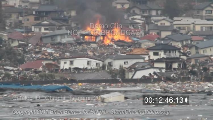
2011 Tōhoku earthquake and tsunami
On March 11, 2011, the town was devastated by a 9.0 magnitude earthquake and tsunami. The tsunami obliterated the harbor and low-lying areas, while higher parts of the town were spared, though they did suffer damage from the earthquake and the many aftershocks. About half the city was inundated by the tsunami. The tsunami destroyed all but 30 of 650 fishing boats and completely wiped-out the town's sea farm industry.
City firemen manually closed the 12 water gates in the port's tsunami wall, but the wall was unable to hold back the waves. Eight city firemen were dead or missing. As of 31 August 2011, 799 residents of the town were confirmed dead, with 608 others still missing, about 10% of the town's total population of 16,000.
The University of Tokyo's ICRC sustained extensive damage during the tsunami with water reaching the laboratories on the third floor.
Town mayor Koki Kato was last seen at a safety meeting with city officials on Friday. His body was recovered on Saturday, 19 March, 2011.
Economy
The local economy is based on commercial fishing and to a lesser extent on agriculture.
Railway
Highway
International relations
As a youth Ken Sasaki noted that his home of Ōtsuchi is located on the same latitude as Fort Bragg, California and in 2001 he contacted then Mayor Lindy Peters and visited with a delegation to open discussions on a sister city agreement. Fort Bragg students visited Ōtsuchi in 2002 and the sister-city proclamation was solidified in 2005 by subsequent Mayor, Dave Turner. Other student exchanges were held in 2004, 2006, 2008 and 2010 and the next exchange was planned for July 2011. Following the 2011 Tōhoku earthquake and tsunami devastation Mayor Turner ordered that city flags be flown half staff until the end of March to honour the thousands of lives lost.