
- Tree Japanese red pine Area 1,259 km² | Population 55,041 (Sep 2015) | |
 | ||
- Flower Montauk daisy (Nipponanthemum nipponicum) Weather 2°C, Wind N at 26 km/h, 78% Humidity | ||
Miyako (宮古市, Miyako-shi) is a city located in Iwate Prefecture, in the Tohoku region of northern Japan. As of September 2015, the city had an estimated population of 55,041 and a population density of 43.7 persons per km2. The total area was 1,259.15 square kilometres (486.16 sq mi).
Contents
- Map of Miyako Iwate Prefecture Japan
- Geography
- Neighboring municipalities
- History
- 2011 Thoku earthquake and tsunami
- Economy
- Education
- Railway
- Highway
- Port
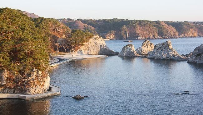
- Local attractions
- International relations
- Noted people from Miyako
- References
Map of Miyako, Iwate Prefecture, Japan
Geography
Miyako is located in central Iwate Prefecture, bordered by the Pacific Ocean to the east, where the Hei River (閉伊川, Heigawa) flows into Miyako Bay. It is connected to Morioka by an east-west train line and highway and the coastal highway also goes through the town. The city has a small port but much of the shipping traffic is taken by larger cities along the coast. Parts of the coastal area of the city are within the borders of the Sanriku Fukkō National Park. The easternmost point of Honshu island is at Cape Todo (魹ヶ崎, Todogasaki) in Miyako.
Neighboring municipalities
History
The area of present-day Miyako was part of ancient Mutsu Province, and has been settled since at least the Jomon period. The area was inhabited by the Emishi people, and came under the control of the Yamato dynasty during the early Heian period with the construction a fortified settlement on the coast. During the Sengoku period, the area was dominated by various samurai clans before coming under the control of the Nambu clan during the Edo period, who ruled Morioka Domain under the Tokugawa shogunate. During the Boshin War of the Meiji restoration, the Battle of Miyako Bay was one of the major naval engagements of the war.
The towns of Miyako and Kuwagasaki were established within Higashihei District on April 1, 1889. The area was devastated by a 18.9 metres (62 ft) tsunami in 1896, which killed 1859 inhabitants. Higashihei District became part of Shimohei District on April 1, 1897. Miyako and Kuwagasaki merged on April 1, 1924. On March 3, 1933, much of the town was destroyed by the 1933 Sanriku earthquake, which killed 911 people and destroyed over 98% of the buildings in the town. Miyako attained city status on June 20, 1940.
On June 6, 2005, Miyako absorbed the town of Tarō, and village of Niisato (both from Shimohei District), more than doubling the old city's size. On January 1, 2010, Miyaki absorbed the village of Kawai (also from Shimohei District).
2011 Tōhoku earthquake and tsunami
On March 11, 2011, Miyako was devastated by a tsunami caused by the 2011 Tōhoku earthquake. Only about 30–60 boats survived from the town's 960 ship fishing fleet. A subsequent field study by the University of Tokyo's Earthquake Research Institute revealed that the waters had reached at least 37.9 metres (124 ft) above sea level, almost equaling the 38.2 metres (125 ft) meter record of the 1896 Sanriku earthquake tsunami. The final reported death toll from the disaster was 420 confirmed dead, 92 missing, and 4005 buildings destroyed.。
Some of the most iconic footage of the tsunami, repeatedly broadcast worldwide, was shot in Miyako. It shows a dark black wave cresting and overflowing a floodwall and tossing cars, followed by a fishing ship capsizing as it hit the submerged floodwall and then crushed as it was forced beneath a bridge.
Economy
The local economy of Miyako was based heavily on commercial fishing and food processing.