
Area rank 223 in Norway Area 457 km² Population 15,633 (2005) | Demonym(s) Eikværing Local time Sunday 6:00 AM | |
 | ||
Weather 1°C, Wind W at 3 km/h, 94% Humidity Points of interest Fossesholm, Nøstetangen Museum, Drammenselva | ||
Øvre Eiker is a municipality in Buskerud county, Norway. It is part of the traditional region of Eiker. The administrative centre of the municipality is the village of Hokksund. The old municipality of Eiker was divided into Øvre Eiker (upper Eiker) and Nedre Eiker (lower) on 1 July 1885.
Contents
- Map of C398vre Eiker Norway
- Name
- Coat of arms
- Geography
- Energy
- Notable residents
- Twin towns Sister cities
- References
Map of %C3%98vre Eiker, Norway
Name
The Old Norse form of the name was Eikjar. The name is the plural form of eiki which means "oak wood". The meaning of Øvre Eiker is "(the) upper (part of) Eiker". (The municipality of Eiker was divided in 1885.)
Coat-of-arms
The coat-of-arms is from modern times. They were granted on 24 October 1981. The arms show three silver oak leaves and two acorns on a blue background. The oak is a canting element, since Eik means oak in the Norwegian language.
(See also coat-of-arms of Eigersund, Nedre Eiker, Songdalen and Tingvoll)
Geography
The municipality is located in the southern part of Buskerud county and is bordered by the municipalities of Kongsberg, Flesberg, Sigdal, Modum, Lier, Nedre Eiker, and Hof.
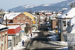
The administrative center of Hokksund is the largest town in this municipality, with about 8,000 inhabitants. The remaining 7,000 inhabitants live in the villages of Vestfossen, Skotselv, Ormåsen, and Darbu.
Energy
Hakavik Power Station, startpoint of 55 kV single phase AC grid for traction current.
Notable residents
Twin towns — Sister cities
The following cities are twinned with Øvre Eiker: