
Area rank 190 in Norway Area 562 km² Local time Monday 6:49 AM | Demonym(s) Flesberging Population 2,512 (2004) | |
 | ||
Weather 1°C, Wind S at 6 km/h, 86% Humidity | ||
Flesberg is a municipality in Buskerud county, Norway. It is part of the traditional region of Numedal. The administrative centre of the municipality is the village of Lampeland.
Contents
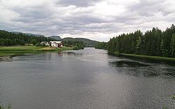
Map of Flesberg, Norway
The economy of Flesberg is dominated by forestry and agriculture, as well as the cluster of high-tech industries in neighbouring town of Kongsberg.
Name
The municipality (originally the parish) is named after the old Flesberg farm (Old Norse: Flesberg), since the first church was built here. The first element is fles which means "rock" and the last element is berg which means "mountain".
Coat-of-arms
The coat-of-arms is from modern times. They were granted on 10 March 1989. The arms show two tømmerklaver to represent forestry - and also the letter F.
History
The Flesberg stave church was built around the year 1250.
The municipality of Flesberg was established on 1 January 1838 (see formannskapsdistrikt). The area of Jondalen was transferred from Flesberg to the neighboring municipality of Kongsberg on 1 January 1964.
Geography
The municipality is divided into the parishes Flesberg, Lyngdal, and Svene. Most of the population lives in the four villages of Svene, Lampeland, Flesberg, and Lyngdal. The municipal area is 560 square kilometres (220 sq mi).
In the western part of Flesberg, the landscape rises steeply to the mountain area of Blefjell, a popular tourist destination.
Sister cities
The following cities are twinned with Flesberg: