
Country Canada Mission founded 1846 Time zone CST Area 23.84 km² Mayor Duane Favel | Trading Post 1776 School founded 1860 Postal code S0M 1C0 Population 1,365 (2011) | |
 | ||
Weather 9°C, Wind S at 10 km/h, 50% Humidity | ||
Île-à-la-Crosse is a northern village located in the boreal forest of northwest Saskatchewan. Situated on a peninsula on the western shore of Lac Île-à-la-Crosse it is accessed by Highway 908 off of Highway 155. It is located within the Northern Saskatchewan Administration District.
Contents
Map of %C3%8Ele-%C3%A0-la-Crosse, SK, Canada
The Cree name for Île-à-la-Crosse is Sakitawak which means "where the rivers meet".
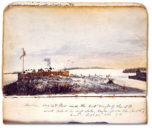
History
Île-à-la-Crosse is the second oldest community in Saskatchewan, Canada, The community has a rich history being connected to the Churchill River, Beaver River and Canoe River systems.
It became the administrative centre of the English River District of the Hudson's Bay Company and an important supply depot on the fur trade route during the latter part of the 18th century and most of the 19th century. The English River District headed by the Chief Factor of Île-à-la-Crosse included other posts on Beaver Lake in Alberta and on Green Lake, Lac La Loche and Lac la Ronge in Saskatchewan.
In 1846 a Roman Catholic mission was established by Father Alexandre-Antonin Taché and Father Louis-François Richer Laflèche of the Oblate Order. and in 1860 three Grey Nuns arrived founding a school and a hospital.
On April 27, 1885, during the North-West Rebellion most of the personnel and dependants of the Hudson's Bay Company Post and the Roman Catholic Mission of Île-à-la-Crosse alarmed at the looting of the Green Lake Post the previous day walked 80 kilometres across the frozen lake and set up a camp on a small wooded island north of Patuanak. On May 24 they erected a large cross on their island of refuge (now known as Cross Island (55°59′46.1″N 107°40′26.9″W) and returned to the community on May 29 when the crisis was over and the lake was free of ice.
Sara Riel the sister of Louis Riel is buried in Île-à-la-Crosse. Sara became a Grey Nun in 1868 and took the name of Sister Marguerite-Marie in 1872. She served at the mission from 1871 to 1883. Her headstone in French reads: Ici Repose Rév. Sœur Marguerite Marie (Riel) Decédée 27 Decembre 1883, Agée 34 ans, R.I.P. Louis Riel Sr. the father of Sara and Louis was born in Île-à-la-Crosse in 1817.
Île-à-la-Crosse celebrated its bi-centennial in 1976.
For geography and fur trade history see Lac Île-à-la-Crosse.
The site was designated a National Historic Site of Canada in 1954.
Demographics
The population of this northern village was 1,365 in 2011. Most are Métis people descendants of French, Scottish, Scandinavian and Cree settlers.
In the 2006 census 1,240 or 93% of the residents identified themselves as Aboriginal.
Education
Île-à-la-Crosse has two schools Rossignol Elementary Community School (Pre-K to Grade 6) designed by architect Douglas Cardinal and Rossignol High School (Grade 7-12) located in the Île-à-la-Crosse Integrated Services Centre a large complex which also includes a hospital, a daycare, senior's care and offices. The schools are within the Île-à-la-Crosse School Division No. 112.