
Area rank 85 in Norway Area 1,171 km² Local time Sunday 12:48 AM | Administrative centre Ål Demonym(s) Åling Population 4,716 (2015) | |
 | ||
Weather 4°C, Wind W at 13 km/h, 72% Humidity Points of interest Torpomoen leir, Gallery Syningen, Apartment in Ål Ski Centre, Reineskarvet | ||
Ål is a municipality in Buskerud county, Norway. It is part of the traditional region of Hallingdal. The administrative centre of the municipality is the village of Ål.
Contents
- Map of C385l Municipality Norway
- Geography
- General information
- Name
- Coat of arms
- Attractions
- Famous people from l
- Sister cities
- References
Map of %C3%85l Municipality, Norway
The parish of Aal was established as a municipality on 1 January 1838 (see formannskapsdistrikt). The area of Hol was separated from the municipality of Aal in 1877 to become a separate municipality.
Geography
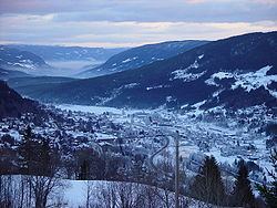
80% of Ål municipality is at least 900 meters above sea level. The highest point is Raudbergnuten at 1819m. Reineskarvet, the significant mountain of Ål has a summit of 1791m. In the winter, Ål has over 400 km of prepped cross country ski trails.
Ål borders the municipalities of Hol, Gol, Hemsedal, Nes, Nore og Uvdal, and Lærdal.
Bergensbanen, the rail line between Oslo and Bergen runs through Ål. Ål Station has an elevation of 436m and is the halfway station on Bergensbanen.
Hallingdalselva runs in the bottom of the main valley, forming Strandafjorden, a long, narrow lake for several kilometers. Ål has several hydroelectric dams. Hallingdalselva runs partly in a tunnel from here to Nes municipality, where it drives a large turbine power plant.
General information
Approximately 5,000 inhabitants spread over several smaller villages including Ål, Torpo, Leveld, Vats, Trillhus, Granhagen, Breie and Strand. Large cultural tradition, folk-music is a big part of peoples identity. Folkemusikkveka is held every May for a week.
The traditional industry of Ål is mostly small-farming. Many livestock farms are still in operation with small herds of sheep, dairy cattle, and goats. Crop growing is difficult because of the steep valley walls, but wheat, barley, rye, and potatoes have all been grown in the past.
Hallingdølen, an award-winning local paper, has offices in Ål village. It comes on Tuesdays, Thursdays, and Saturdays. Ål has a Videregående school and a Folkehøyskole for deaf students.
Name
The Old Norse form of the name was Áll. The name is identical with the word áll which means "ditch" or "gully". In 1921, the spelling of the name was changed from "Aal" to "Ål".
Coat-of-arms
The coat-of-arms is from modern times. They were granted on 30 November 1984. The arms show three silver diamond shapes in a vertical line on a red background. The designs are taken from an old and common pattern used in hand-woven tapestries in the area. They also symbolize the three churches in the municipality: Ål, Torpo, and Leveld.
Attractions
Famous people from Ål
Sister cities
The following cities are twinned with Ål: