
Primary inflows Catchment area 4.068 km (1.571 sq mi) Surface elevation 724 m Length 5.4 km | Area 7.3 km² | |
 | ||
Similar Zugerberg, Lorze, Raten Pass, Wildspitz, Sihlsee | ||
4k lake gerisee zug switzerland dji airview
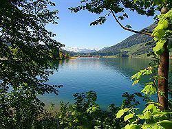
Ägerisee (or Lake Aegeri) is a glacial lake in the Canton of Zug, Switzerland. The two municipalities along its shore are Oberägeri and Unterägeri. The main tributary is the Hüribach; the Lorze river drains the Ägerisee. Since 1992 the lake is used as a water reservoir.
Contents
- 4k lake gerisee zug switzerland dji airview
- Map of Lake C384geri Switzerland
- 4k autumn lake gerisee zug switzerland
- References
Map of Lake %C3%84geri, Switzerland
The Battle of Morgarten took place in 1315 on the shores of the Ägerisee.
4k autumn lake gerisee zug switzerland
References
Ägerisee Wikipedia(Text) CC BY-SA