Harman Patil (Editor)

Zummar

Updated on
Edit
Like
Comment
Share on FacebookTweet on TwitterShare on LinkedInShare on Reddit
Country
  
Iraq

district
  
Tal Afar

Governorate
  
Nineveh Governorate

Zummar wwwpukonlinecomhawpechekanzummarjpg

Zummar (also written Zemar or Zumar) (Arabic: زمار‎‎) is both the name of an Iraqi subdistrict located in north Nineveh Governorate and of its seat, the city of Zummar. The population is a mix of Arabs and Kurds, most of them work in agriculture. Wheat is the prime crop there.
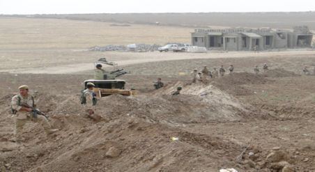
In August 2014, Zummar subdistrict fell to ISIL's hands. In August 2014 Zumar was recaptured by Peshmerga on Battle of Zumar

Contents

Map of Zummar, Iraq

Zummar town

Zummar town is the seat of Zummar subdistrict, it is located 60 km north west of Mosul city at the west bank of the river Tigris. Its population is 50,000 inhabitants.

Oil fields

The Zummar subdistrict is rich with oil. It contains two oil fields, both run by North Oil Company, yield crude sort of heavy crude oil.

  • Ain zala oilfield was explored by British company in 1939. It is 16 km long and 4 km wide. The production delayed after World War II until 1951 when the Mosul oil company branch of Iraq Petroleum Company started production with 20,000 barrels per day but the production degraded later to 5,000 barrels per day right now.
  • Batma oil field was discovered by Mosul oil company, a branch of Iraq Petroleum Company 1953. The oilfield is 12 km long and 6 km wide. The production commenced in that year with 5.0000 barrels per day. The production has been stopped since 1990 due to the United Nations' financial and trade embargo ('sanctions') against Iraq after its invading Kuwait, resume of production has been postponed further after the Iraq war. Batma is considered a small field compared with other Iraqi fields, where its potential production not more than 5.000 barrel per day.
  • References

    Zummar Wikipedia