
First ascent 1900 | Elevation 2,645 m | |
 | ||
Listing Alpine mountains 2500-2999 m Similar Saulakopf, Schesaplana, Drusenfluh, Drei Türme, Sulzfluh | ||
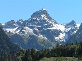
The Zimba, elevation 2,645 m (8,678 ft), is the most familiar mountain in the Austrian mountain range called Rätikon. Located in the hinterland of Bludenz, this horn is the landmark of Montafon valley and especially of the main village of Schruns. Three ridges and three walls emphasize the shapeliness of the form. The eastern ridge is one of the most familiar climbing routes of the whole Rätikon range, but the normal way leads along the western ridge. Despite the altitude of just 2,645 m, the Zimba is a great viewpoint for the entire region.
Contents
Map of Zimba, 6773 B%C3%BCrs, Austria
Climbing routesEdit
References
Zimba (mountain) Wikipedia(Text) CC BY-SA