
Postal code 235 Population 414,356 (Jan 2016) | Time zone CST (UTC+8) Area 20.29 km² Local time Monday 4:09 AM | |
 | ||
Weather 14°C, Wind E at 10 km/h, 58% Humidity Points of interest Zhonghe Yuantong Temple, Ba'ersan Memorial Park, Nanyang Sightseeing Food Street, Jiasui Park, Xiushan Park | ||
Ximending taipei travel guide
Zhonghe District (Chinese: 中和區; Hanyu Pinyin: Zhōnghé Qū; Tongyong Pinyin: Jhonghé Cyu, Pe̍h-ōe-jī: Tiong-hô Khu), historically spelled Chung-Ho and Jhonghe, is an inner city district in New Taipei in northern Taiwan (Republic of China). Zhonghe is a burgeoning satellite city of Taipei.
Contents
- Ximending taipei travel guide
- Map of Zhonghe District New Taipei City Taiwan
- Geography and climate
- History
- Administrative divisions
- Rail
- Road
- Education
- Economy
- Cultural and religious sites
- Burma Street
- Famous natives
- Twin towns sister cities
- References
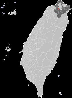
Map of Zhonghe District, New Taipei City, Taiwan
Geography and climate
Zhonghe lies just south-west of Taipei City and shares borders with Banqiao, Xindian, Tucheng and Yonghe Districts of New Taipei City, as well as Taipei City. The average annual temperature is 21.7 °C (71.1 °F) and the precipitation averages 2,111 millimetres (83.1 in) per year. Most of Zhonghe lies a few tens of meters above sea level and is heavily urbanized, with forested hillier country in the southeast. A mountainous ridge forms most of the eastern border with Xindian, which includes the highest point in Zhonghe, the 302-meter Fenglusai (Chinese: 風爐塞山; pinyin: Fēnglúsài Shān).
History
The present-day area of Zhonghe District was originally settled by aboriginal tribes. During conflict between the colonial forces of the Dutch and the Spanish, the area is recorded by the Dutch as Chiron, from the name of one of the tribes living there. This name is preserved in one of the constituent villages of the city, called Xiulang Li (秀朗里), and the bridge which connects Zhonghe to Xindian.
The area was subsequently settled by Han Chinese migrants from Fujian but remained relatively unimportant until the end of the Second World War. In 1946 the population of the area of present-day Zhonghe and Yonghe was 30,000 and it was classified as a rural township.
Due to rapid population growth Yonghe was separated from Zhonghe in 1958. Subsequently, on January 1, 1979, Zhonghe was upgraded to county-controlled city status after reaching a population of 170,000. On 25 December 2010, due to the changing from Taipei County to New Taipei City, Zhonghe City was changed to Zhonghe District.
Administrative divisions
Zhonghe is divided into 93 villages, which are further subdivided into lín (鄰; "neighbourhoods"), of which there are 2,972 in total. Some administration is shared with neighbouring Yonghe District; due to both this and their proximity, they are sometimes collectively known as Shuanghe (雙和; "Twin He"). This is also reflected in the names of various institutions such as Shuang-Ho Hospital in Zhonghe and Shuanghe Libai Church in Yonghe.
Rail
Zhonghe is served by the Zhonghe Line of the Taipei Metro, three stations of which are located in the city: Yongan Market, Jingan and the terminal station, Nanshijiao. Scheduled to begin operation in June 2018, the Circular Line will add a further five metro stations in Zhonghe, and transform Jingan Station into an interchange station between the Circular and Zhonghe lines. Further into the future, the Wanda Line and the North-South section of the Yellow Line will eventually bring the number of MRT stations in Zhonghe to fifteen. The closest regular rail and high-speed services are from Banqiao Station in neighbouring Banqiao District.
Road
Zhonghe has an interchange on one of Taiwan's two main north-south road arteries; the National Highway 3. Also providing road links is Provincial Highway 64, an elevated expressway that cuts through the middle of the district, with several on and off-ramps in Zhonghe itself. There are two bridges over the Xindian River; Xiulang Bridge, which connects Zhonghe with Xindian, and Huazhong Bridge, reaching Taipei's Wanhua District.
Education
Zhonghe is home to the National Taiwan Library, which is located in the grounds of the 8-23 Memorial Park. It has one of the best collections in Taiwan of factual books about Taiwan in English.
There are nine elementary schools, four junior high schools, one senior high school, and three private high schools in Zhonghe. The Hwa Hsia University of Technology is also located in the city.
Economy
The offices of a number of technology companies are located in the district, including the Asia-Pacific head office of Viewsonic, SpotCam, a Texas Instruments research facility, the head offices of Cooler Master, and Micro-Star International.
Cultural and religious sites
Burma Street
Huaxin Street (華新街), near Nanshijiao MRT Station, is home to a large proportion of Taiwan's small Burmese immigrant population. Zhonghe District is home to 40,000 Burmese Chinese (2008), making up 10% of Zhonghe's population, and constituting one of the largest communities of Burmese Chinese outside of Burma. Consequently, there are numerous stores and restaurants in this area selling Burmese produce and there are also cultural events on occasion.
Famous natives
Twin towns — sister cities
Zhonghe, Taiwan is twinned with: