
Elevation 889 m | Municipality Jezersko Traditional region Carinthia Local time Sunday 7:25 PM | |
 | ||
Weather 14°C, Wind S at 3 km/h, 51% Humidity | ||
Zgornje Jezersko ([ˈzɡoːɾnjɛ jɛˈzɛːɾskɔ], literally 'Upper Jezersko'; German: Ober-Seeland) is a settlement and administrative centre of the Municipality of Jezersko in northern Slovenia. It is part of the traditional Slovenian Carinthia region and the Upper Carniola Statistical Region.
Contents
Map of 4206 Zgornje Jezersko, Slovenia
Geographical features
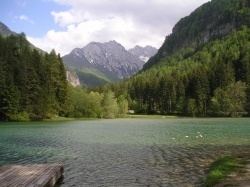
The settlement is located in a high valley between the Karawanks mountain range in the north and the Kamnik–Savinja Alps in the south. The road from Kranj runs through the valley further up to Seeberg Saddle and the border with Austria.
Jezernica Creek, a tributary of the Kokra river, flows through Zgornje Jezersko. Other major geographical features in or bordering the settlement's territory include Lake Planšar (Planšarsko jezero), the Ravni Combe (Ravenska Kočna), Makek Combe (Makekova Kočna), Kokra Combe (Kokrska Kočna), and Jezersko Combe (Jezerska Kočna), as well as the Grintovec, Skuta and Storžič peaks in the south.
Churches
There are three churches in the settlement. Two of them, including the parish church, are dedicated to Saint Oswald. The older one, a chapel of ease above the village, was built around 1320. The larger 19th-century church is on the northern outskirts of the main settlement.
St. Andrew's Church, another chapel of ease, is located in the hamlet of Ravne, northeast of the main settlement. There is also a chapel dedicated to Saint Hubertus in the settlement.