
Highest elevation 20 m (70 ft) Elevation 20 m | Total islands One Population Uninhabited | |
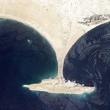 | ||
Zalzala Koh (Earthquake Mountain) or Zalzala Jazeera (Earthquake Island) was a small island off the coast of the port city of Gwadar, Balochistan, Pakistan which appeared on 24 September 2013 following an earthquake. As predicted by many geologists, the island has started to resubmerge, with satellite images indicating the island has sunk 3 m (10 ft) into the sea since its initial appearance. By end of 2016, the island had completely disappeared.
Contents
Map of Zalzala Island, Pakistan
Formation
Zalzala Koh may be a mud volcano, located in the Arabian Sea offshore of Gwadar in Balochistan, Pakistan. It rose out of the water during a 7.7-magnitude earthquake that struck the same province on 24 September 2013.
Ali Rashid Tabriz, the head of Pakistan’s National Institute of Oceanography, said that the surfacing of the island had been caused by an emission of methane gas on the seabed.
Location
The island is visible from Pakistan's coastline and is about 2 kilometres (1.2 mi) from the shore, with a height of 15 to 20 metres (50 to 65 ft) a length of 175.7 m (576 ft), width of 160.9 m (528 ft), and a surface of 22.726 m2 (244.62 sq ft) (measured from satellite Pleiades). These figures are still debated, though.
Ecology
While the surface is lifeless, the seas around the island have become a haven for fish and other life forms (including the coral Acibaria delicata), which has boosted the local fishing industry.