
ISO 3166 code RS-15 Settlements 173 | Municipalities 3 and 1 city Area 3,623 km² | |
 | ||
Points of interest Balkan Mountains, Ripaljka waterfall, Soko Grad, Felix Romuliana, Gurgusovacka Kula Destinations | ||
The Zaječar District (Serbian: Зајечарски округ, Zaječarski okrug, [zâjɛtʃarskiː ôkruːɡ]) is one of nine administrative districts of Southern and Eastern Serbia. It expands to the eastern parts of Serbia. It has a population of 119,967 inhabitants, according to the 2011 census results. The administrative center is the city of Zaječar.
Contents
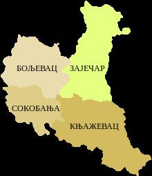
- Map of ZajeC48Dar District Serbia
- Municipalities
- Demographics
- Ethnic groups
- History
- Roman Emperors
- Economy
- References
Map of Zaje%C4%8Dar District, Serbia
Municipalities
It encompasses the municipalities of:
Demographics
According to the last official census done in 2011, the Zaječar District has 119,967 inhabitants.
Ethnic groups
Ethnic groups of the district according to the 2011 census results:
History
Felix Romuliana (Galerius' Palace) in modern Gamzigrad is the birthplace of the Roman Emperor Gaius Galerius Valerius Maxmimianus, in late 3rd century and early 4th century. Because of its archaeological findings, Gamzigrad ranks among the most important late Roman sites in the world. The rich historic material (jewelry, mosaics, coins, tools, arms) found here is a treasure trove of Roman civilization of the 4th century A.D.
Roman Emperors
Three Roman Emperors were born in the Zaječar District:
Economy
Trends of economic development of the Zaječar District lead from crafts and semi-industrial processing of agricultural products over coal exploitation (textile factory, leather factory, brewery, quartz sand mine and coal mine) to the modern plants and high output rate.