
Length 20 mi (32 km) N-W | Width 8 mi (13 km) State Jammu and Kashmir Elevation 3,966 m | |
 | ||
Range coordinates 34°08′N 74°58′E / 34.14°N 74.97°E Coordinates: 34°08′N 74°58′E / 34.14°N 74.97°E | ||
Kashmir paragliding xc flight over the dal lake zabarwan range hd
The Zabarwan Range is a short (20 mi (32 km) long) sub-mountain range between Pir Panjal and Great Himalayan Range in the central part of the Kashmir Valley in the state of Jammu and Kashmir in India.
Contents
Geography
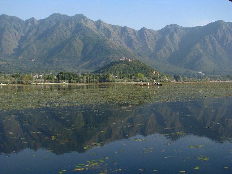
The Zabarwan Range borders the central part of the Kashmir Valley in the east. Literally it is the mountain range between Sind Valley and Lidder Valley on the north and south, and between the Zanskar Range and Jehlum Valley on the east and west, respectively. Specifically the range is known to be what overlooks the Dal Lake and holds the Mughal gardens of Srinagar. The north end of the range lies in Ganderbal, while the south end lies in Pampore. The Shankaracharya Temple is built on the edge of the central part of the Zabarwan Range. The highest peak of this range is Mahadev Peak at 13,013 feet (3,966 m), which forms the distant background of the eastern mountain wall.
On the northern slopes of the central part of the range there are three Mughal gardens built by Emperor Shah Jahan. These include Chashma Shahi, Nishat Bagh and Shalimar Garden alongside the Pari Mahal (the fairy palace). The recently built Indira Gandhi Memorial Tulip Garden in the lap of the Zabarwans is considered the largest tulip garden of Asia spread over 12 hectares of land.
Wildlife
The Zabarwan mountain range possesses great Himalayan features with rich wildlife. The Dachigam National Park, spread over 141 km2, is the main feature of the range. The Dachigam National Park holds the last viable population of Kashmir stag (Hangul) and the largest population of black bear in Asia. The range is also home to musk deer, leopard, Himalayan brown bear, leopard cat, jungle cat, red fox, jackal, Himalayan wolf, serow, Himalayan yellow-throated marten, long-tailed marmot, Indian porcupine, Himalayan mouse-hare, langur and Himalayan weasel.
Climate
The climate of the Zabarwans can be summed up from the climate of Dachigam. It is a sub-Mediterranean type, with two spells of dryness from April to June and September to November. The range has irregular weather conditions with a considerable variation in the amount of precipitation. Snow is the main source of precipitation, and in some parts melts till June. The annual minimum and maximum rainfall of the Zabarwans ranges between 32 mm to 546 mm.
Geology
The crystalline axis of the Himalayan system contains the oldest rocks, and in the northern flank of this crystalline axis are found fossiliferous sediments of marine origin. The Zabarwan Range has crystalline rocks such as granite, schists and phyllites with embedded lime stone, which form the core of its parent range. The western region from Khanmoh to the east of Mahadev consists of shale, calacarious slates and blue limestone. The sediments composing this range have been laid from Cambrian to Tertiary. The soil depth in Dachigam on the slope from lower to middle reaches is less than 25 cm, and hence falls under the category of very shallow soils.