As of May 2015, the city has an estimated population of 79,935 and a population density of 66.1 persons per km². The total area was 1,209.60 square kilometres (467.03 sq mi).
Yurihonjō has a Humid continental climate (Köppen climate classificationCfa) with large seasonal temperature differences, with warm to hot (and often humid) summers and cold (sometimes severely cold) winters. Precipitation is significant throughout the year, but is heaviest from August to October.
After the start of the Meiji period, the area became part of Yuri District, Akita Prefecture in 1878.
The modern city of Yurihonjō was established on March 22, 2005, from the merger of the city of Honjō, and the towns of Chōkai, Higashiyuri, Iwaki, Nishime, Ōuchi, Yashima and Yuri (all from Yuri District). Just after the merger, the new city of Yurihonjō had 126 representatives in its new city assembly, more than the whole of Tokyo.
Economy
The economy of Yurihonjō is based on agriculture and commercial fishing.
Companies headquartered in Yurihonjo
TDK Yurihonjo
Education
Yurihonjō has 15 elementary schools, 10 middle schools and five high schools, as well as one special education school. Akita Prefectural University also has a campus in the city.
Amasagi Village is a complete tourist center in the town of Iwaki, northern Yurihonjō. It is centered on an historical facility, and it contains the samurai residence of the Unuma family (transferred from its original site), and a museum with collections of furniture and samurai armor.
Akata Giant Buddha Statue (赤田大仏,Akata Daibutsu)
A large standing Buddha statue.
Honjō Park (本荘公園,Honjō Kōen)
Each year a large cherry blossom festival (April) and Azalea festival (May) take place here.
Yashio Park (八塩いこいの森,Yashio Ikoi no Mori)
This park is famous for its yellow cherry blossom trees and it holds a firework display in May during full bloom.
A large plateau of outstanding natural beauty on the Akita side of Mount Chōkai. It includes numerous rental cottages and an amusement area.
Taki Hot Spring (滝温泉,Taki Onsen) in the Ōuchi area is reputed to cure minor pains and many sufferers stay there long-term.
Yurihonjo Arena
Honjō Marina & Koyoshi River
Rowing
There are 500 metre & 1000 metre rowing courses at the mouth of the Koyoshi River. A major public regatta takes place here each year in September. Three high schools in Yurihonjō have their own rowing clubs with a history of success in national rowing championships.
Marina, Sailing
Honjō has a wide beach with an adjacent yachting harbour.
Local events
Fireworks
A fireworks festival is held every summer near the mouth of the Koyoshi River.
Naked Festival (裸参り,Hadaka Matsuri)
This religious event takes place in January in which a group of men and boys walk up the Shinzan mountain through the snow to Shinzan Shrine. They wear only loincloths and thin shoes.
Yurihonjō Hinakaidō (由利本荘ひな街道)
In March each year visitors can follow a map of public displays of the traditional Hina dolls at over 50 different locations around the city.
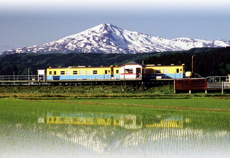
Mount Chōkai
Mount Chōkai (鳥海山,Chōkai-san) is an inactive volcano that stands alone on the border between Akita Prefecture and Yamagata Prefecture. It is 2,236m high and is the second highest mountain in the Tohoku area. It is popular with skiers, hikers and climbers.
There are two main trails for climbing Mount Chōkai from the Akita side. One trailhead is in Nikaho, south of Yurihonjō. The other, in Yurihonjō, starts at the Haraikawa (秡川) Parking Area. A one-way hike from the Haraikawa commonly takes 3 hours and there are bungalows and camping sites on the lower slopes of this trail.
The mountain has its own unique Alpine plants and vegetation such as Chōkai Thistle (チョウカイアザミ) and Chōkai Fusuma (チョウカイフスマ).
Dried noodles which are eaten hot or cold. The texture of Honjō Udon is tough.
Gotenmari ball (ごてんまり,Gotenmari)
These elaborate decorative balls are made from silk thread and are a popular souvenir of Yurihonjō.
Honjō Lacquer (本荘塗り,Honjō-nuri)
A number of craftsmen in Yurihonjō produce traditional lacquerware.
Honjō Oiwake (本荘追分)
This is a traditional folk song, known as min'yō, which is reputed to be one of the most difficult for singers to master. A national Honjō Oiwake competition is held in Yurihonjō every year over 2 days in September.
Mountain vegetables (山菜,sansai)
The foothills of Mount Chōkai produce many varieties of wild mountain vegetables and in spring and autumn it is common to see cars parked on the side of the road as people stop to pick them. Popular mountain vegetables are yamaudo(山ウド), bamboo shoots (笹タケノコ,sasa takenoko) and warabi(ワラビ).