
- Flower silk tree Local time Tuesday 1:32 AM | - Tree Sugi Population 25,530 (May 2015) | |
 | ||
Weather 1°C, Wind N at 6 km/h, 93% Humidity Points of interest | ||
Nikaho (にかほ市, Nikaho-shi) is a city located in Akita Prefecture, in the northern Tohoku region of Japan.
Contents
- Map of Nikaho Akita Prefecture Japan
- Geography
- Neighboring municipalities
- Climate
- History
- Economy
- Education
- Railway
- Highway
- Local attractions
- Parks in Nikaho
- Local events
- Mount Chkai
- Local crafts arts and food
- Sister city relations
- Noted people from Nikaho
- References
Map of Nikaho, Akita Prefecture, Japan
As of May 2015, the city had an estimated population of 25,530 and a population density of 106 persons per km². The total area was 241.13 square kilometres (93.10 sq mi).
Geography
Nikaho is located at the far southwest corner of Akita Prefecture, bordered by the Sea of Japan to the west, and by Yamagata Prefecture to the south. Part of the city is within the borders of the Chōkai Quasi-National Park.
Neighboring municipalities
Climate
Nikaho has a Humid continental climate (Köppen climate classification Cfa) with large seasonal temperature differences, with warm to hot (and often humid) summers and cold (sometimes severely cold) winters. Precipitation significant throughout the year, but is heaviest from August to October.
History
The area of present-day Nikaho was part of ancient Ugo Province, dominated by the Satake clan during the Edo period, who ruled Kubota Domain under the Tokugawa shogunate. After the start of the Meiji period, it became part of Yuri District, Akita Prefecture in 1878.
The modern city of Nikaho was established on October 1, 2005, from the merger of the former towns of Nikaho, absorbing the towns of Kisakata and Konoura (all from Yuri District).
Economy
The economy of Nikaho is based on commercial fishing and agriculture. Industry includes a large factory by the electronics firm TDK.
Education
Nikaho has six elementary schools, three middle schools and one high school.
Railway
Highway
Local attractions
Parks in Nikaho
Local events
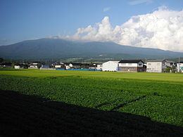
Mount Chōkai
Mount Chōkai is an inactive volcano which stands alone on the border between Akita Prefecture and Yamagata Prefecture. It is 2236 metres high and is the second highest mountain in the Tōhoku area. It is popular with skiers, hikers and climbers.
There are two main trails for climbing Mount Chōkai from the Akita side. One trailhead is in Yurihonjō, Akita, north of Nikaho. The other, in Nikaho, starts at the Nakajima parking area. A one-way hike from the Nakajima commonly takes 4 hours and offers outstanding views of the Japan Sea coast and the lush greenery of the Nikaho area.
The mountain has its own unique Alpine plants and vegetation such as Chōkai Thistle (チョウカイアザミ) or Chōkai Fusuma (チョウカイフスマ).