
Airport type Public 14/32 6,006 1,831 Asphalt Code MYV Phone +1 530-741-6463 | Elevation AMSL 64 ft / 20 m 6,006 1,831 5/23 3,281 Elevation 19 m | |
 | ||
Address 1364 Sky Harbor Dr, Olivehurst, CA 95961, USA | ||
172 take off yuba county airport
Yuba County Airport (IATA: MYV, ICAO: KMYV, FAA LID: MYV) is a county owned airport in Yuba County, California, three miles southeast of Marysville, California. The National Plan of Integrated Airport Systems for 2011–2015 categorized it as a general aviation facility.
Contents
- 172 take off yuba county airport
- Golden west fly in airshow yuba county airport 2013
- History
- Facilities
- References
Golden west fly in airshow yuba county airport 2013
History
The Civil Aeronautics Board, and as authorized by Public No. 812, 76th Congress, approved the construction of Alicia Airport and the City of Marysville and the County of Yuba jointly purchased 833 acres for this purpose. Alicia Airport was built in 1941 by contractor L. D. Richardson and Co. of Beverly Hills, California.
In March 1942 the City of Marysville and County of Yuba leased the airport and its 833 acres to the Army Air Forces to serve as air support command base for Marysville Cantonment (later named Camp Beale) and designated as Marysville Army Airfield. Marysville Army Air Field was used for a short time as a sub-base of Hamilton Field and controlled by the IV Fighter Command. One major unit served at Marysville Army Airfield, the 369th Fighter Group, a Replacement Training Unit that trained on A-36 Apaches, P-39 Airacobras, and P-40 Warhawks. The group had three fighter squadrons, the 398th, 399th, and 400th.
It served there from November 5, 1943 until they moved to Oroville Army Airfield in January 1944. Marysville Army Air Field was eventually transferred to the Air Technical Service Command and was vacated.
In 1946 the City of Marysville released all interest in the airport to Yuba County, and in August 1947, through the War Assets Administration, Marysville Army Airfield was released to Yuba County. Yuba County Airport was licensed as an approved airport on September 30, 1949 by the State of California and continues to operate as a municipal airport and industrial park.
Airline flights: Southwest Airways and its successors from the late 1940s until about 1970.
Facilities
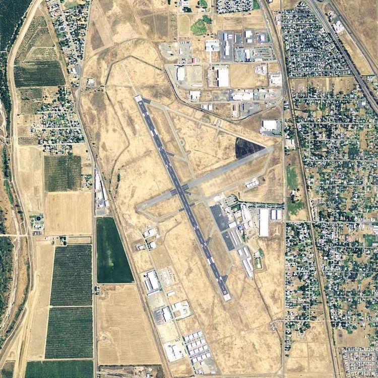
Yuba County Airport covers 933 acres (378 ha) at an elevation of 64 feet (20 m). It has two asphalt runways: 14/32 is 6,006 by 150 feet (1,831 x 46 m) and 5/23 is 3,281 by 60 feet (1,000 x 18 m).
In the year ending June 30, 2010 the airport had 35,300 aircraft operations, an average of 96 per day: 99% general aviation and 1% air taxi. 61 aircraft were then based at this airport: 90% single-engine, 8% helicopter, and 2% ultralight.