
 | ||
West yorkshire regiment world war i in the ypres salient
The Ypres Salient is the area around Ypres in Belgium which was the scene of some of the biggest battles in World War I.
Contents
- West yorkshire regiment world war i in the ypres salient
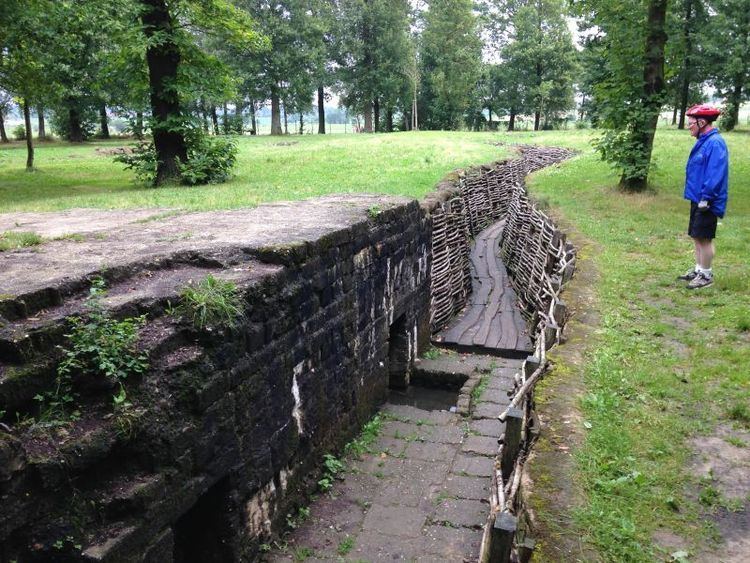
- Souvenir hill 60 ypres salient belgium wwi
- Ypres district
- Ypres Salient
- References
Souvenir hill 60 ypres salient belgium wwi
Ypres district
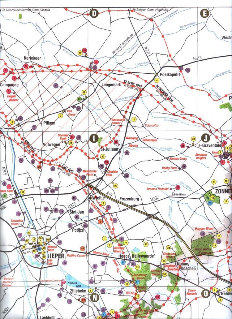
Ypres lies at the junction of the Ypres–Comines Canal and the Ieperlee. The city is overlooked by Kemmel Hill in the south-west and from the east by low hills running south-west to north-east with Wytschaete (Wijtschate), Hill 60 to the east of Verbrandenmolen, Hooge, Polygon Wood and Passchendaele (Passendale). The high point of the ridge is at Wytschaete, 7,000 yd (6,400 m) from Ypres, while at Hollebeke the ridge is 4,000 yd (3,700 m) distant and recedes to 7,000 yd (6,400 m) at Polygon Wood. Wytschaete is about 150 ft (46 m) above the plain; on the Ypres–Menin road at Hooge, the elevation is about 100 ft (30 m) and 70 ft (21 m) at Passchendaele. The rises are slight apart from the vicinity of Zonnebeke, which has a 1:33 gradient. From Hooge and to the east, the slope is 1:60 and near Hollebeke, it is 1:75; the heights are subtle but have the character of a saucer lip around Ypres. The main ridge has spurs sloping east and one is particularly noticeable at Wytschaete, which runs 2 mi (3.2 km) south-east to Messines (Mesen), with a gentle slope to the east and a 1:10 decline to the west. Further south is the muddy valley of the Douve river, Ploegsteert Wood ("Plugstreet" to the British) and Hill 63. West of Messines Ridge is the parallel Wulverghem (Spanbroekmolen) Spur; the Oosttaverne Spur, also parallel, is to the east. The general aspect south of Ypres is of low ridges and dips, gradually flattening to the north into a featureless plain.
In 1914, Ypres had 2,354 houses and 16,700 inhabitants inside medieval earth ramparts, faced with brick and a ditch on the east and south sides. Possession of the higher ground to the south and east of the city, gives ample scope for ground observation, enfilade fire and converging artillery-fire. An occupier also has the advantage of artillery deployments and the movement of reinforcements and supplies being screened from view. The ridge had woods from Wytschaete to Zonnebeke, giving good cover, some being of notable size like Polygon Wood and those later named Battle Wood, Shrewsbury Forest and Sanctuary Wood. The woods usually had undergrowth, but the fields in gaps between the woods were 800–1,000 yd (730–910 m) wide and devoid of cover. Roads in this area were usually unpaved, except for the main ones from Ypres, with occasional villages and houses. The lowland west of the ridge was a mixture of meadow and fields, with high hedgerows dotted with trees, cut by streams and ditches emptying into the canals. The Ypres–Comines Canal is about 18 ft (5.5 m) wide and the Yperlee about 36 ft (11 m); the main road to Ypres from Poperinge to Vlamertinge is in a defile, easily observed from the ridge.
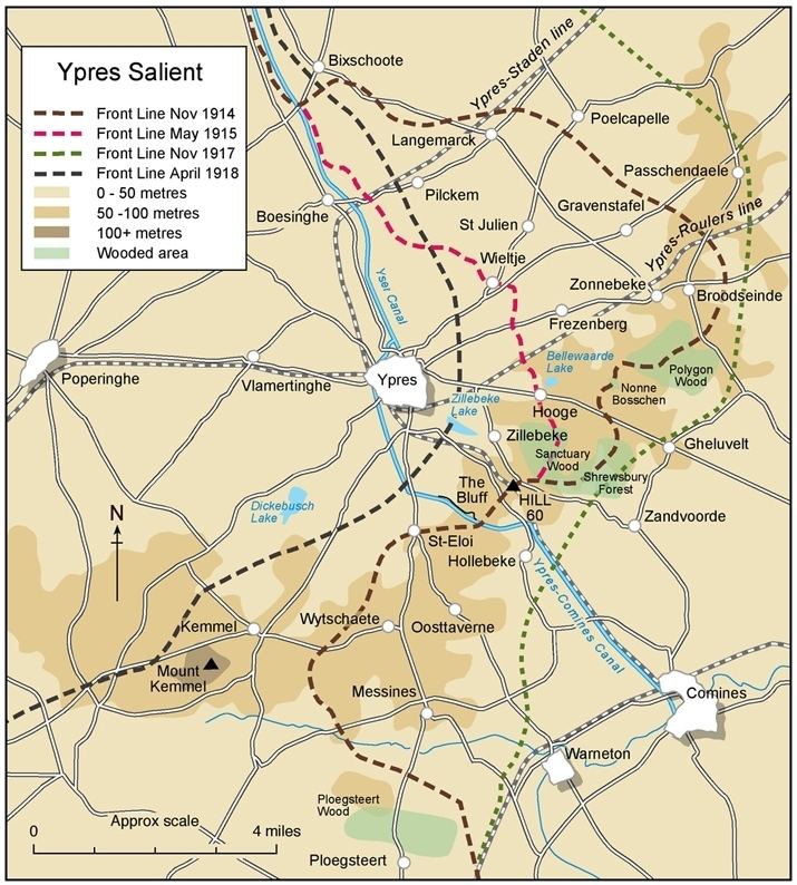
Ypres Salient
A salient in military terms is a battlefield feature that projects into an opponent's territory. The salient is surrounded on three sides, making the troops occupying the salient vulnerable. The Ypres Salient was formed by British, French, Canadian and Belgian defensive efforts against German incursion during the 1914 "Race to the Sea", culminating in the Battle of the Yser and the First Battle of Ypres.
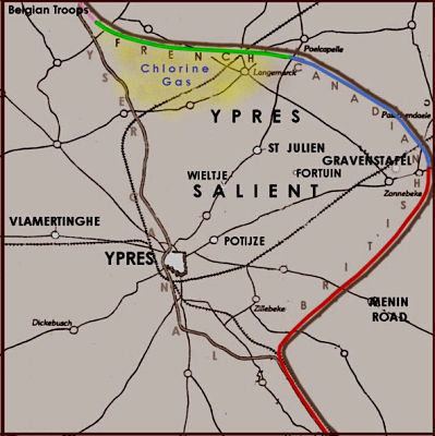
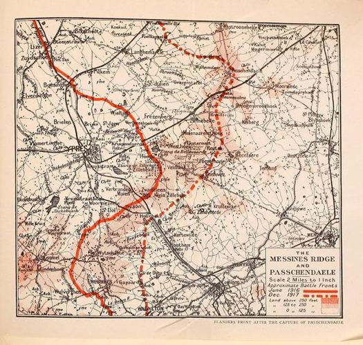
The battles saved Ypres and the corner of Belgium around Veurne from German occupation, but also led to the beginning of trench warfare in the salient as both sides "dug in" around the line. The few rises or hills became the objectives of the Second Battle of Ypres in 1915, which saw the first use of gas and the almost total destruction and evacuation of Ypres. During this battle, the Allied units were forced to draw back from Zonnebeke and St Julien to a line of trenches closer to Ypres. This line was to define the Ypres Salient for over two years, during which Hooge lay in one of the eastern-most sectors of the salient and was much contested. This situation changed little despite British tunnelling prior to the Battle of Messines in June 1917 and the Third Battle of Ypres at Passchendaele from July to November.
After the Third Battle of Ypres, the Ypres Salient was left relatively quiet until the Fourth Battle of Ypres (Battle of the Lys), when the German Spring Offensive threatened to overwhelm the entire area. This offensive was stopped at the point the Allies were closest to being forced to abandon the salient. By August 1918, the Fifth Battle of Ypres (part of the Hundred Days Offensive) pushed the German forces out of the salient entirely and they did not return.