
Elevation 1,743 m (5,718 ft) Postal code 76500 Population 672 (2012) Area code 0476 | District Aralık Time zone EET (UTC+2) Vehicle registration 76 Local time Sunday 2:40 AM | |
 | ||
Weather 1°C, Wind S at 5 km/h, 62% Humidity | ||
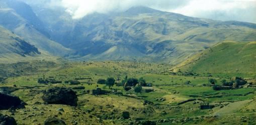
Yenidoğan (Armenian: Ակոռի Akori; Kurdish: Axurî; Russian: Ахури) is a village in eastern Turkey, on the northeastern slope of Mount Ararat, adjacent to the point where the borders of Turkey, Iran, and Armenia meet. It was formerly known as Ahora until 1965 and as Akhuri under Russian administration, before the Treaty of Kars. It was also known as Arguri. The village is a part of the Aralık district of Turkey's Iğdır Province, which largely corresponds to the historic region of Surmali. It is nearly 50 kilometers south of Yerevan, the Armenian capital.
Contents
- Map of YenidoC49Fan 76500 YenidoC49Fan KC3B6yC3BC2FAralC4B1k2FIC49FdC4B1r Turkey
- Etymology
- History
- Geography and climate
- Demographics
- References
Map of Yenido%C4%9Fan, 76500 Yenido%C4%9Fan K%C3%B6y%C3%BC%2FAral%C4%B1k%2FI%C4%9Fd%C4%B1r, Turkey
Etymology
The name "Yenidoğan" literally means "newborn" in the Turkish language. Baltic German explorer Friedrich Parrot speculated that the historic name of "Akhuri" had Biblical origins and derived from the local Armenian tradition that the grapevines of the village were planted by Noah after he descended from the Ark. "The Armenian name of the village contains a distinct allusion to that occurrence," wrote Parrot, "arghanel, in that language, means to set or plant, whence argh, he planted, and urri, the vine." This theory was rejected by French Caucasus scholar Marie-Félicité Brosset.
History
Numerous examples of ancient, early Proto-cuneiform glyphs have been found on rocks in the vicinity of Yenidoğan.
It was from this village in 1829 that Friedrich Parrot, Armenian writer Khachatur Abovian, and four others reached the top of Mount Ararat in the first recorded ascent in history. They used the Armenian monastery of St. Hakob as their base. The monastery was later destroyed in the earthquake of 1840.
Geography and climate
Yenidoğan is situated on the northeastern slope of Mount Ararat at an altitude of 1,743 metres (5,718 ft). It is notable for the 1800 meters deep Ahora (or Akhuri) Gorge, a massive canyon on the north side of Ararat. The village has a highly fluctuating climate with extreme temperatures and a highly variable precipitation.
Demographics
The population of Akhuri was predominately ethnic Armenian until the village was destroyed in the 1840 earthquake. The reestablished Akhuri was repopulated mostly by ethnic Kurds from neighboring villages. Modern Yenidoğan is today a predominately Kurdish village.