
Elevation 1,400 m (4,590 ft) Postal code 51000 Population 504 (2011) | Time zone EET (UTC+2) Licence plate 51 Area code 0388 | |
 | ||
Yeşilburç (former Teney) is a village in Niğde Province, Turkey.
Contents
- Map of YeC59FilburC3A7 51000 YeC59FilburC3A7 KC3B6yC3BC2FNiC49Fde Merkez2FNiC49Fde Turkey
- Geography
- History
- Economy
- References
Map of Ye%C5%9Filbur%C3%A7, 51000 Ye%C5%9Filbur%C3%A7 K%C3%B6y%C3%BC%2FNi%C4%9Fde Merkez%2FNi%C4%9Fde, Turkey
Geography
At 38°01′N 34°40′E Yeşilburç is only 5 kilometres (3.1 mi) north of Niğde and 5 kilometres (3.1 mi) south of Gebere Dam. Situated in a high valley, it is surrounded by fruit gardens. The population of the village is 504 as of 2011.
History
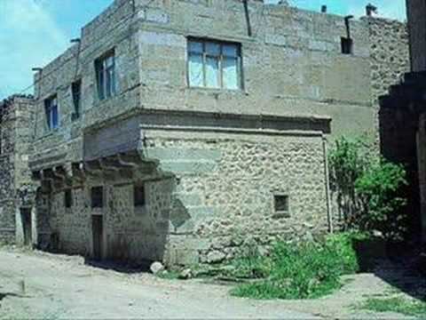
Yeşilburç was a Karamanlides village; i.e., the residents were Turkish speakers of Orthodox Christian faith. But during the compulsory population exchange between Greece and Turkey (Turkish: mübadele) in 1920s, they were deported to Greece just like the Greeks. In Greece they were settled in Corfu island (in Ionian Sea, west of Greece) . Meanwhile Turks from the village of Irakleotes (Turkish: Krifçe) in Grevena (north Greece) who were deported from Greece came to Turkey to find a new home. They were settled in Yeşilburç in 1926.
Economy
Fruits are the main products of Yeşilburç. The village is especially specialised in apple production. The touristic potential is also high for there are many historical buildings (from Karamanlides) in the village. But at the present tourism plays no role in the village economy