
Population 369 (2011 census) Unitary authority Area 63 ha | OS grid reference SU5574 Local time Monday 10:02 AM | |
 | ||
Weather 10°C, Wind NW at 18 km/h, 57% Humidity | ||
Yattendon
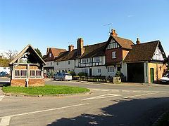
Yattendon is a geographically small village and civil parish 7 miles (11 km) northeast of Newbury, Berkshire. The M4 motorway passes through the fields of the village which lie 0.5 miles (800 m) south and below the elevations of its cluster.
Contents
Map of Yattendon, Thatcham, UK
Geography
Yattendon stretches from Everington in the west to the hamlet of Burnt Hill in the east and the woodland just east of Yattendon Court, including Mumgrove Copse, Bushy Copse, Clack's Copse and Gravelpit Copse. The motorway forms most of its southern boundary and some of the houses on the northern edge of Frilsham are actually in Yattendon. The River Pang flows through the west of the parish. It was in the hundred of Faircross, which was of little consequence after the Dissolution of the Monasteries and effectively ceased to function after 1886.
Yattendon Castle
The village had a fortified manor house or castle, Yattendon Castle. It was home of:
Other notable residents of Yattendon include: