
Time zone EST (UTC-5) Area 576 km² | Established 1912 Elevation 30 m Local time Monday 2:08 AM Area code(s) +53-23 | |
 | ||
Weather 23°C, Wind NE at 14 km/h, 78% Humidity | ||
Yara is a small town and municipality in the Granma Province of Cuba, located halfway between the cities of Bayamo and Manzanillo, in the Gulf of Guacanayabo. Yara means "place" in the Taíno language.
Contents
Map of Yara, Cuba
History
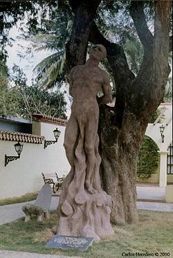
The Taíno Cacique (chief) Hatuey was burnt at the stake in Yara, on February 2, 1512, after he organized a guerrilla war against the Spaniards. Hatuey is known as "Cuba's First National Hero". This action gave birth to one of Cuban mayor's myths; "La Luz de Yara", The Light of Yara.
On October 10, 1868, the beginning of the Ten Years' War in Cuba occurred and is known as El Grito de Yara (The Cry of Yara) and was the beginning of the First Cuban War of Independence.
Yara was established as a municipality in 1912, when Manzanillo was split up.
Geography
The municipality is divided into the barrios of Yara, Yara Arriba, Veguitas, Coco, Caboa, Cabagán, Calambrosio and Canabacoa.
Demographics
In 2004, the municipality of Yara had a population of 59,415. With a total area of 576 km2 (222 sq mi), it has a population density of 103.2/km2 (267/sq mi).