
Length 266 km | ||
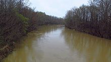 | ||
The Yalobusha River is a river, 165 miles (266 km) long, in north-central Mississippi in the United States. It is a principal tributary of the Yazoo River, via which it is part of the watershed of the Mississippi River.
Contents
Map of Yalobusha River, Mississippi, USA
The name "Yalobusha" comes from the Choctaw word yalooboshi, meaning "little tadpole", from yalooba, "tadpole", and -ushi, "diminutive". The United States Board on Geographic Names settled on the river's name in 1892. According to the Geographic Names Information System, it has also been known as "Yallabusha" and as the "Yellowbushy River."
CourseEdit
The Yalobusha River rises in Chickasaw County, northwest of the town of Houston, and flows generally west-southwestwardly through Calhoun, Grenada and Leflore Counties, past the town of Grenada. At Greenwood it joins the Tallahatchie River to form the Yazoo River.
Much of the Yalobusha's course through Calhoun County has been straightened and channelized; this section of the river is also known as the "Yalobusha River Canal." In Grenada County, the river is impounded by a U.S. Army Corps of Engineers dam to form Grenada Lake, which collects the Yalobusha's largest tributary, the Skuna River.