
Peak Shōgatake Length 25 km (16 mi) Highest point Mt. Shogatake | Elevation 908.3 m (2,980 ft) Width 10 km (6.2 mi) | |
 | ||
Mountains Mount Yōrō, Tadosan, Mt Shogatake | ||
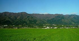
The Yōrō Mountains (養老山地, Yōrō Sanchi) are a mountain range straddling the border between Gifu and Mie prefectures in Japan. They form part of the western border of the Nōbi Plain.
Contents
Geography
The Yōrō Mountains stretch approximately 10 km (6 mi) wide and 25 km (16 mi) long, with the primary direction of the mountains running from the south-southwest to the north-northeast. The highest peaks in the northern section of the mountains reach up to 900 m (2,953 ft) high, while peaks in the southern section only reach 400 m (1,312 ft). The tallest mountain in the group is Mount Shō (笙ヶ岳 Shō-ga-dake), but the main peaks are Mount Yōrō in the north and Mount Tado (多度山 Tado-yama) in the south.
Flora and fauna
There are a variety of beech and oak trees covering the Yōrō Mountains. Mount Shō has been declared a natural monument by the Japanese government because of its diverse plant life.
Major mammals on the mountains include the Japanese macaque and sika deer.
Places of interest
On the Yōrō Line, between Mino-Yamazaki Station and Komano Station, on the side of Mt. Garyou, a Buddhist temple was built by Gyōki in 744 AD. It was originally called Temple of the Bodhisattva of Mt. Garyou. It was burned down in 1336 during a war, but was rebuilt in 1705 by the local Matsudaira nobility as their private temple and renamed Gyōkiji (Gyōki's Temple).
Near Yōrō town, on the side of Mount Yōrō is the Yōrō waterfall and a large park with two special parks for children. There is also a hiking path to the top of the mountain.
Tado Shrine is located near the town of Tado. There are hiking paths to the top of Mount Tado. Tado-san is 403 meters tall.