
Status Operational Opening date 1935 Surface area 5,390 ha (13,300 acres) Annual generation 42.9 GWh (154 TJ) | Construction began 1928 Construction cost A£1.352 million Height 85 m Normal elevation 379 m (1,243 ft) AHD Dam volume 3,580 m3 (126,000 cu ft) | |
 | ||
Owner(s) State Water Corporation Similar Burrendong Dam, Burrinjuck Dam, Windamere Dam, Keepit Dam, Carcoar Dam | ||
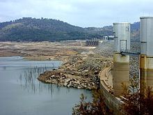
Wyangala Dam is a major gated rock fill with clay core embankment and gravity dam with eight radial gates and a concrete chute spillway across the Lachlan River, located in the south-western slopes region of New South Wales, Australia. The dam's purpose includes flood mitigation, hydro-power, irrigation, water supply and conservation. The impounded reservoir is called Lake Wyangala.
Contents
- Map of Wyangala Dam Wyangala NSW 2808 Australia
- Location and features
- Power generation
- History
- References
Map of Wyangala Dam, Wyangala NSW 2808, Australia
Location and features
Commenced in 1928, completed in 1935, and upgraded in 1971, Wyangala Dam is a major reservoir situated below the confluence of the Lachlan and Abercrombie rivers, located approximately 38 km (24 mi) upstream, east of Cowra. The dam was built by the New South Wales Water Conservation & Irrigation Commission to supply water for irrigation, flood mitigation and potable water for the towns of Cowra, Forbes, Parkes, Condobolin, Lake Cargelligo, Euabalong and Euabalong West. The dam also provides water for a far larger area and operates in conjunction with Lake Brewster and Lake Cargelligo, to supply water to the lower Lachlan valley customers.
The dam wall constructed with 3,580 m3 (126,000 cu ft) of rockfill and a clay core is 85 m (279 ft) high and 1,370 m (4,490 ft) long. The maximum water depth is 79 m (259 ft) and at 100% capacity the dam wall holds back 1,220,000 ML (43,000×10^6 cu ft) of water at 379 m (1,243 ft) AHD. The surface area of Lake Wyangala is 5,390 ha (13,300 acres) and the catchment area is 8,300 km2 (3,200 sq mi). The eight radial gates and concrete chute of the spillway are capable of discharging 14,700 m3/s (520,000 cu ft/s). A A$43 million upgrade of facilities commenced in 2009 and, when completed by 2016, is expected to result in the raising and locking of the spillway radial gates; raising of the spillway chute wall; and raising of the parapet wall crest.
The Wyangala Dam is the second oldest dam built for irrigation in New South Wales and was one of the last dams in the state where a railway or tramway system for construction purposes was utilised. It is the only dam on the Lachlan River system, which feeds the Murrumbidgee River, and in turn feeds the Murray River.
Power generation
A hydro-electric power station generates up to 22.5 MW (30,200 hp) of electricity from the flow of the water leaving Wyangala Dam with an average output of 42.9 GWh (154 TJ) per annum. A 7.5 MW (10,100 hp) station was initially constructed below the dam wall and opened in 1947, and the new facility, managed by Hydro Power Pty Ltd, completed in 1992.
History
The name Wyangala is said to originate from an indigenous Wiradjuri word of unknown meaning and is the name of Wyangala Station, one of the properties flooded by Lake Wyangala waters when construction of the dam was completed in 1935. The Wyangala Station homestead site, which was originally settled by the Newham family, is under the water level and can only be seen when the dam is close to being dry. The small settlement of Wyangala, located downstream of the dam wall, was established to house workers during the dam construction.
The current earth and rock wall was constructed between 1961 and 1971 due to fears that the original dam wall was beginning to lift away from its base, and as a result, would not be able to withstand a major flood. The original dam wall can be seen when the water level is around 30 per cent of the reservoir's catchment capacity.
In 2008, water entitlements were down to just 10 per cent of normal availability. Some inflows to the reservoir later in the year allowed restrictions for high security licence holders to be relaxed. In late 2009, drought had reduced the water storage level to 4.5 per cent of the reservoir's capacity.