
OS grid reference SK4020 Sovereign state United Kingdom Local time Thursday 6:18 AM Dialling code 01530 | Civil parish Worthington | |
 | ||
Population 1,350 (parish) (2001 Census) Weather 3°C, Wind SW at 10 km/h, 97% Humidity | ||
Worthington is a village and civil parish in North West Leicestershire, England, about 4 miles (6.4 km) north of the town of Coalville and a similar distance north-east of the market town of Ashby-de-la-Zouch. The population of the civil parish (including Gelsmoor , Griffydam and Newbold) at the 2011 census was 1,461. The village is about 5 miles (8 km) from East Midlands Airport and junction 23a of the M1 motorway where it meets the A42 road. The parish also includes the hamlet of Newbold.
Contents
Map of Worthington, UK
History
Worthington's toponym may derive from the family name "Werden" or a man called "Weorth".
The Domesday Book of 1086 records Henry de Ferrers as holding four carucates of land at "Werditone".
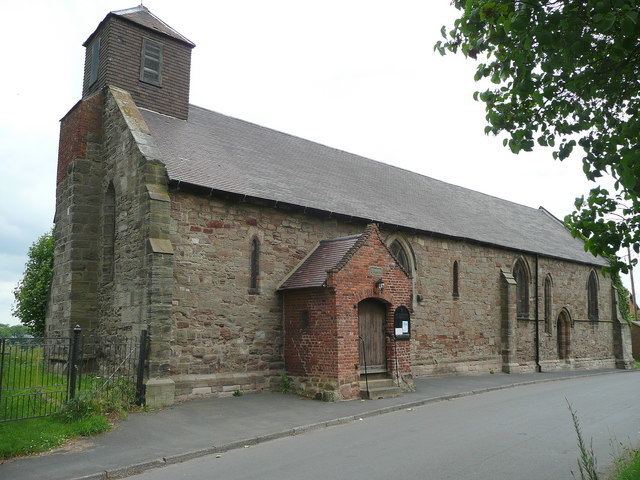
The Church of England parish church of Saint Matthew is Norman. Most of its present windows were added in the 13th century and the remainder were added in about 1300. Fragments remain of a Perpendicular Gothic screen that was added later in the Middle Ages. St. Matthew's is now part of the United Benefice of Breedon and Worthington.
The parish lock-up is believed to have been built late in the 18th century. It is an octagonal building with an octagonal spire but is called the Round House. It is built of brick and is a scheduled monument.
Worthington Methodist Chapel was built in 1820.
In 1874 the Midland Railway extended its Melbourne branch through Worthington parish to Ashby-de-la-Zouch and opened Worthington railway station to serve the village. The Midland's successor the London, Midland and Scottish Railway withdrew the line's passenger service in the 1930s and British Railways closed the line to freight traffic in 1980.
Worthington Primary school opened in about 1926. The school use an image of the 'Round House' as their logo.
The parish was predominantly rural until the 20th century, when the village was rapidly expanded to house workers for nearby collieries including New Lount Colliery. By the 1990s many of the local collieries had ceased operating and the village began to lose its mining identity.
Local nicknames for Worthington have included "Paraffin City" due to its late adoption of electricity, and "Yawny Box" which is an obsolete Derbyshire word for a donkey.
Amenities
Worthington has a public house, the Malt Shovel Inn. It used to have another pub called the Swan.
The village has a post office.
National Cycle Route 6 passes through the parish, and at the site of the former railway station it joins the trackbed of the former railway to Melbourne, Derbyshire. In the parish the cycle route is called the Cloud Trail.
The parish is in the hunting country of the Quorn Hunt.