
- elevation 0 m (0 ft) Secondary source Waratah Rivulet | - elevation 353 m (1,158 ft) Basin area 174 km² Bridges Woronora River Bridge | |
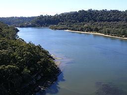 | ||
- location between Como and Illawong | ||
Woronora river kayaking
The Woronora River is a perennial river of the Sydney Basin, located in the Sutherland Shire local government area of Greater Metropolitan Sydney, approximately 22 kilometres (14 mi) south of the Sydney central business district, in New South Wales, Australia.
Contents
- Woronora river kayaking
- Map of Woronora River New South Wales Australia
- Woronora river
- Location and featuresEdit
- EtymologyEdit
- References
Map of Woronora River, New South Wales, Australia
Woronora river
Location and featuresEdit
The Woronora River rises on the northwestern slopes of the Illawarra escarpment and has its origin from Waratah Rivulet, near Darkes Forest, and flows generally north for approximately 36 kilometres (22 mi), joined by three minor tributaries, before reaching its confluence with the Georges River, between Como and Illawong. The total catchment area of the river is approximately 174 square kilometres (67 sq mi) and the area is generally administered by the Sydney Catchment Authority in its upper reaches and the Sutherland Shire Council in its lower reaches. Much of the course of the river is through the Dharawal State Conservation Area, Heathcote National Park and the Royal National Park as it descends 354 metres (1,161 ft) from source to mouth.
The river is impounded by the Woronora Dam, opened in 1941. The 71,790-megalitre (2,535×10^6 cu ft) impoundment is Lake Woronora, formed to augment water supply for southern Sydney and the northern Illawarra region.
The Woronora River is traversed by high level and low level road bridges and a footbridge in the suburb of Woronora. A road bridge on Heathcote Road, linking Heathcote and Holsworthy also provides a crossing over the river. At the area known as "The Needles", near Woronora Road in Engadine, a footbridge links the suburb to Barden Ridge. Comment from an ex resident: "The Needles" were considered the "head of navigation" where there was relatively deep water with pointed vertical rocks, mostly just below the surface, hence the name. There was a causeway there which was part of "The Old Illawarra Rd". This area is below the Heathcote Rd bridge by about 3/4 km. Just above this road bridge was "Woronora Wier" which was demolished in the mid 1900s for safety reasons. I learned to swim there as a 5 year old in around 1948.
EtymologyEdit
In the Australian Aboriginal Dharug language the river draws its name, meaning "black rocks". 'Woronora' is an Aboriginal place name. Records show the spelling of the name has varied since it first appeared in the 19th century, the earliest being Wooloonora (Dixon, 1827, quoted in Walker 1974:66, followed by Wolonora (Dixon, 1837, and Woronora Mitchell, 1835). The name was first applied to the Woronora River, a tributary of the Georges River, before being given to an electoral district, a local road east of the river, and finally the suburb itself.