
Official name Woodstock Dam Opening date 1982 Catchment area 1,171 km² Impound Tugela River | Type of dam Earth fill dam Height 54 m Surface area 29.16 km² | |
 | ||
Purpose Industrial and domestic Owner Department of Water and Sanitation Similar Kilburn Dam, Spioenkop Dam, Sterkfontein Dam, Zaaihoek Dam, Wagendrift Dam | ||
Bass fishing south africa bett ep 18 2012 kzn teaser woodstock dam
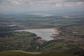
Woodstock Dam is located on the upper reaches of the Tugela, KwaZulu-Natal province of South Africa and is the main source of water for the Thukela-Vaal Transfer Scheme. The dam was commissioned in 1982, has a storage capacity of 373.26 million cubic metres (13.182×10^9 cu ft), and a surface area of 29.129 square kilometres (11.247 sq mi), the dam wall is 54 metres (177 ft) high. The dam serves mainly for municipal and industrial water supply purposes and its hazard potential has been ranked high (3).
Contents
- Bass fishing south africa bett ep 18 2012 kzn teaser woodstock dam
- Map of Woodstock Dam Hoffenthal South Africa
- References
Map of Woodstock Dam, Hoffenthal, South Africa
References
Woodstock Dam Wikipedia(Text) CC BY-SA