
Official name Kilburn Dam Type of dam earth-fill Length 1,100 m (3,600 ft) Opened 1981 Turbine 4 | Opening date 1981 Impounds Majaneni River Height 48 m Catchment area 30 km² | |
 | ||
Owner Department of Water and Sanitation Similar Woodstock Dam, Sterkfontein Dam, Bezuidenhouts Pass, Spioenkop Dam, Zaaihoek Dam | ||
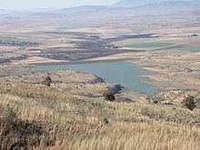
The Kilburn Dam, an earth-fill type dam and part of the Tugela-Vaal Water Project and Drakensberg Pumped Storage Scheme, is located 500 metres (1,600 ft) lower than the Sterkfontein Dam, on the Mnjaneni River, near Bergville, KwaZulu-Natal, province of South Africa. The dam was commissioned in 1981, has a capacity of 36,700 cubic metres (1,300,000 cu ft), and a surface area of 207 hectares (510 acres), the dam wall is 48 metres (157 ft) high. The main purpose of the dam assembly is to serve for the generation of hydro-electricity and its hazard potential has been ranked high (3).
Map of Kilburn Dam, South Africa
References
Kilburn Dam Wikipedia(Text) CC BY-SA