
Population 21,010 Sovereign state United Kingdom | OS grid reference SE361290 Local time Wednesday 3:06 PM | |
 | ||
Weather 13°C, Wind W at 23 km/h, 60% Humidity | ||
Rothwell and woodlesford leeds
Woodlesford is a village in the metropolitan county of West Yorkshire, England, 6 miles (10 km) south-east of Leeds city centre. It is in the City of Leeds metropolitan borough. Woodlesford was formerly part of the Rothwell Urban District. The village now falls within the Rothwell Ward of the Leeds Metropolitan Council. The village sits on the banks of the Aire and Calder Canal and river system.
Contents
- Rothwell and woodlesford leeds
- Map of Woodlesford Leeds UK
- Woodlesford lock aire valley leeds flood aerial video 2015
- History
- Community
- Transport
- Education
- References
Map of Woodlesford, Leeds, UK
Woodlesford lock aire valley leeds flood aerial video 2015
History
The name is first attested between 1188 and 1202, in the form Widlesford, with other medieval forms including Wryd(e)lesford(e). These other forms are closer to the likely origin: Old English *wrīdels 'thicket' + ford 'ford'. The ford in question must have been on the road from Tadcaster to Wakefield, crossing the River Aire.
Much of Woodlesford's expansion took place from the nineteenth century as a mining village. Woodlesford contained four operational pits at Bower's Row by 1896, all owned by T & R W Bower Ltd and managed by W S Blackburn. There was also mining at Rothwell Colliery. When coal production ceased in 1983 the area declined though recovered in large part due to its position for commuters.
The village was the home of Bentley's Yorkshire Bitter, until the brewery was acquired by Whitbread plc in 1968 and closed down four years later. The Bentley family built the brewery, Eshald Mansion and All Saints Church. The Church opened in 1880s and closed in the 1990s. It has since been redeveloped as a house and the Mansion divided into flats.
Originally Woodlesford was separated from the neighbouring village of Oulton but this is no longer the case due to the residential expansion of both villages. The official boundary between the two villages runs through the centre of the Midland Hotel public house, along Midland Street and then across to Holmsley Field Lane. This places Oulton Library in Woodlesford and Woodlesford Post Office in Oulton. Woodlesford, however, is much larger than Oulton. Woodlesford also extends as far as Bowers Row, formerly the St Aidan's Colliery, and across to the M62.
Community
Woodlesford is now a residential part of the commuter belt that services the city of Leeds. It once had a number of industries, including its own pottery, match factory, quarries, and Brewery. It was divided into two parts "Old Woodlesford" and "New Woodlesford". The old part of the village is situated to the north of a park on the hill and contains the school, the chapel and former church. New Woodlesford related to the area on Aberford Road which is now dominated by 19th-century terraces, a Co-op store and a butcher's.
At the centre of the village is a small park which contains a football pitch, children's play area and skatepark. The closest sports facility is Rothwell Sports Centre in neighbouring Oulton. There are three village public houses and other pubs and restaurants in the nearby area. In 2010, one of the village's public houses, The White Hart on Church Street closed to the public and was demolished; it was Woodlesford's largest pub. The village contains a post office, petrol station, convenience store, library, three newsagents and other shops and food outlets. Some people in the area travel to Leeds or Wakefield for recreation.
The village has its own Army Cadet Force unit (part of Yorkshire North & West ACF) which is based adjacent to Oulton Library and the playing field/skate park.
Transport
Woodlesford railway station to the north-east of the village provides trains to Leeds, Barnsley, Sheffield and Goole from which services link to major cities throughout the country.
The station operates 7 days a week, with services on the Hallam Line (Leeds to Sheffield); and the Pontefract Line (Leeds to Knottingley, with limited services continuing to Goole). The service connects to Leeds City Centre, with a journey time of 8 minutes. Other services connect the village to Castleford, Normanton, Glasshoughton, Pontefract Monkhill, Knottingley, Wakefield Kirkgate, Darton, Barnsley, Wombwell, Elsecar, Chapeltown, Meadowhall Interchange and Sheffield.
Between quarters 3 and 4 of the calendar year, the steam-powered Scarborough Spa Express train operates services to Scarborough on Tuesdays and Thursdays, calling at Woodlesford railway station. Passengers spend three hours at Scarborough before the return journey.
Major roads are situated nearby including the M1, M62, A1 and an M1/A1 link road.
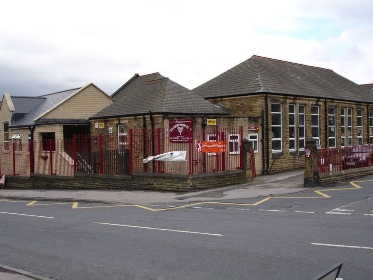
Education
Most primary age children in the area attend the local Woodlesford Primary School. The school dates to the nineteenth century and has expanded the number of buildings on site including a major development in recent years. In 2004 Woodlesford Primary School was 24th overall in the Leeds area primary school rankings. Other children attend the Oulton Primary School. Most children between 11 and 16 attend the nearby Royds School in Rothwell; others commute further to either Brigshaw High School, The Rodillian Academy or Garforth Academy.