
Postcode(s) 4873 Population 746 (2011 census) | LGA(s) Douglas Shire Council Postal code 4873 Local time Wednesday 8:54 PM | |
 | ||
Weather 28°C, Wind SE at 37 km/h, 72% Humidity | ||
Wonga Beach is a small rural residential town, north of Cairns in Queensland Australia.
Contents
- Map of Wonga QLD 4873 Australia
- Geography
- Fauna
- Population
- Services
- Caltex service station
- Wonga Beach State School and Preschool
- School buses
- References
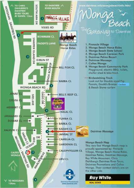
Map of Wonga QLD 4873, Australia
Geography
Wonga Beach is a beachside town situated between the small residential towns of Rocky Point (sometimes referred to as Dayman Point) and the Daintree township. It is approximately 17 kilometres (11 mi) north of the town of Mossman. In 1985 a large volcanic eruption beneath the Coral Sea released thousands of Pumice stones to the ocean surface which were then blown along north Queensland's shore by the trade winds.
Fauna
Birdwatchers visit Wonga Beach to see three uncommon bird species: Gould's bronze cuckoo, double-eyed fig-parrot and the beach stone-curlew. The last species is easily confused with the ubiquitous bush stone-curlew noted for its wailing calls at night.
Population
Wonga Beach has 746 as of the 2011 census.
Services
Wonga Beach has a small number of services spread throughout the area.
Caltex service station
In addition to automotive fuels, the service station incorporates a small convenience store with an ATM. The site was previously run as a British Petroleum and before that Mobil but changed to Caltex in 2007. Nearby there are picnic tables, a post box, telephone booth and a display of model cassowaries. In 2011 three shops were added to the complex. A pharmacy opened, and the other shops are available to rent. The Caltex service station is the only fuel outlet in the Daintree Valley and opens early (5:30am) and closes at 8:30pm.
Wonga Beach State School and Preschool
The Wonga Beach state school is one of the few primary schools in the Mossman area with an enrolment of approximately 115 students (now part of the Cairns Region), and has been operating since 1999. The previous school was based at Rocky Point, about 4 kilometres (2.5 mi) south, and the old school buildings have been sold as housing, one of which has been relocated to Wonga Beach. The school is known as a SunSmart school (an initiative of The Cancer Council Australia), enforcing strict rules on UV-protection. The school has a large area of swampland, the maintenance of which has been made a school project, with an 'eco-maze' currently being developed in the site.
School buses
School buses run twice daily from New Wonga to Old Wonga, then on to Mossman. These buses are not available to the public.