
 | ||
Similar Bondi Beach, Darling Harbour, The Rocks, Sydney Harbour Bridge, Royal Botanic Garden | ||
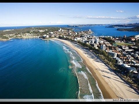
Manly beach sydney new south wales australia
Manly Beach is a beach situated among the Northern Beaches of Sydney, Australia in Manly, New South Wales. From north to south, the three main sections are Queenscliff, North Steyne, and South Steyne.
Contents
Map of Manly Beach, New South Wales, Australia
The beach was named by Capt. Arthur Phillip for the indigenous people living there. Philip wrote that "[the indigenous people's] confidence and manly behaviour made me give the name of Manly Cove to this place".
Within walking distance of Manly Beach along the oceanway is Fairy Bower and Shelley Beach. There are shops, restaurants, night clubs, and dive bars in town.
Manly Council Lifeguards operate a year-round service at South Steyne, and operate from October to April at North Steyne and Queenscliff. Volunteer Life Savers also patrol on weekends and public holiday between October and May.
Travelling to Manly from Sydney's main ferry terminal, Circular Quay, takes 30 minutes by public ferry. There is also the option of a private ferry from Circular Quay to Manly (and back) between Monday and Saturday. There are two private ferry services running (also called "fast ferries") and the trip takes 18 minutes. The Corso, a pedestrian plaza and one of Manly's main streets for shopping and dining, runs from the ferry wharf and harbour beach, across the peninsula to Manly Beach, where it marks the boundary between North Steyne and South Steyne.