
OS grid reference SP525655 District Borough of Rugby Postcode district CV23 | Sovereign state United Kingdom Local time Wednesday 3:30 AM Population 284 (Parish 2011 Census) | |
 | ||
Shire county WarwickshireNorthamptonshire Weather 4°C, Wind NW at 11 km/h, 90% Humidity Shire counties | ||
Wolfhampcote is an abandoned village and civil parish in the English counties of Warwickshire and Northamptonshire, which it straddles. The population of the civil parish at the 2011 census was 284.
Contents
Map of Wolfhampcote, UK
The old village of Wolfhampcote is located west of the A45 road near Braunston in Northamptonshire, and can be reached by a track from the main A45 road, or by a lane from Flecknoe. The village was abandoned sometime in the late 14th century and is classified as a deserted medieval village. Local legend suggests that the village was wiped out by the Black Death brought in by refugees from London, but there is no evidence to support this. It is much more likely that a few cottages still remained after the great plague and after struggling to maintain their land the villagers drifted off to more prosperous places leaving the Lord of the Manor to clear the land for sheep grazing as best he could. The village is shown as Wulfencote on the Christopher Saxton map of 1637.
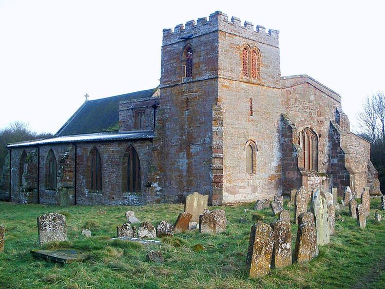
Today the only remains of the village are a cottage, a farmhouse, and the old vicarage, located some distance away. The most notable surviving feature of the village is the Church of St Peter, which stands apparently in the middle of nowhere in a field. The church has been restored on several occasions, most recently in the 1970s by an organisation called the Friends of Friendless Churches. The church is today managed by the Churches Conservation Trust and is used only once or twice a year.
The area around the old village is rich in industrial archaeology. The Oxford Canal passes to the north of the site, but this section is the result of a straightening-out dating from the 1830s, the more southerly original route (constructed in the 1770s) having followed a much more winding course, remains of which can still be traced through the area. There are also the remains of two abandoned railway lines, the first being the old Weedon to Leamington Spa (via Daventry) railway, part of the London and North Western Railway (later the LMS), which closed to passengers in September 1958 and to freight in December 1963, and the second being the Great Central Main Line, which closed to all traffic in September 1966. The former passes quite close to the south side of the church. The two lines crossed a short distance to the west.
The parish
The old village gives its name to a civil parish in Rugby Borough, which includes the nearby villages of Flecknoe and Sawbridge. In 2001, the parish had a population of 263. Flecknoe is the largest settlement in the parish.