
 | ||
Similar Good Harbor Beach, Beauport, Stage Fort Park, Eastern Point Light, Hammond Castle | ||
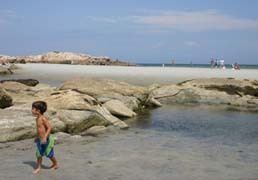
Wingaersheek beach gloucester ma the view
Wingaersheek Beach is a 0.6-mile (0.97 km) long beach located on the Annisquam River in West Gloucester, Massachusetts, United States.
Contents
- Wingaersheek beach gloucester ma the view
- Map of Wingaersheek Beach Gloucester MA 01930 USA
- Wingaersheek beach gloucester ma
- References
Map of Wingaersheek Beach, Gloucester, MA 01930, USA
According to the USGS the name is a corruption of the earlier Dutch name "Wyngaerts Hoeck", which was derived from "Wyngaerton" (meaning "Vineland"). The name was described by Professor Trumbull as "not Indian" but stated by Professor E. N. Horsford to be "an undoubted corruption of the German (Low Dutch) name, "Wyngaerts Hoeck", which occurs on many maps between 1630 and 1670, especially in Ogilby's "America"." The beach was alternatively called Coffins Beach for Peter Coffin whose farm was located alongside this beach."
The popularity of Wingaersheek beach, as well as the nearby Good Harbor Beach has resulted in traffic jams in the area. Furthermore, since January 2015, a local law came into place that forbids from unleashing dogs on Wingaersheek beach on even numbered days and on the Good Harbor Beach on odd numbered days.