
- elevation 164 ft (50 m) - average 494 cu ft/s (14 m/s) Basin area 184.7 km² | - elevation 7 ft (2 m) Basin area 184.7 km² | |
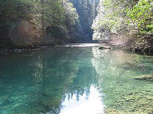 | ||
Source confluence of Bear and Salmon creeks | ||
Nice day at beach october 3rd 2012 brookings oregon winchuck river backed up with sand again
The Winchuck River (Tolowa: duu-sr-xuu-shi taa-ghin-li~’) is a short coastal stream that runs through the Rogue River–Siskiyou National Forest to the Pacific Ocean in the U.S. states of Oregon and California. Flowing generally west from its origin near Elk Mountain, the river enters the sea at Crissey Field State Recreation Site, about 1⁄2 mile (0.80 km) north of the Oregon–California border and about 5 miles (8 km) south of Brookings.
Contents
- Nice day at beach october 3rd 2012 brookings oregon winchuck river backed up with sand again
- Map of Winchuck River Oregon USA
- Sept 30 2012 warm up in forest trees oregon brookings winchuck river
- Works citedEdit
- References
Map of Winchuck River, Oregon, USA
Formed by the confluence of Fourth of July Creek and Bear Creek in southern Curry County, the river flows generally west. Just below the source, Salmon Creek enters from the left, then Elk Creek and Deer Creek enter from the right. Further downstream, the Winchuck receives Moser Creek and the South Fork Winchuck River, both from the left. The river then leaves Oregon, flowing in Del Norte County, California, for a short distance before re-entering Oregon. The Winchuck passes under U.S. Route 101 in Oregon just before reaching the ocean. Winchuck River Road runs along or near the north side of the river for much of its course.
The main stem and tributaries support chinook and coho salmon, steelhead, and sea-run coastal cutthroat trout. Access for fishing is limited, especially along the lower stretches of the river. Fishing from boats is not allowed, but Winchuck River Road provides public access in places.
Flora in the watershed's forests include Douglas-fir, bigleaf maple, and madrone, typical of the Southern Oregon Coast Range, the coastal Siskiyou Mountains, and the Redwoods Zone. Most of Oregon's remaining coast redwood forest lies within the Winchuck drainage. Sensitive fauna in the watershed include the spotted owl and marbled murrelet.