
Intercommunality Boulonnais Area 7.71 km² Local time Monday 10:45 PM Area1 7.71 km2 (2.98 sq mi) | Time zone CET (UTC+1) Population 7,493 (1999) Population (2014)2 6,996 Arrondissement Boulogne-sur-Mer | |
 | ||
Weather 7°C, Wind S at 8 km/h, 92% Humidity | ||
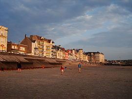
Places to see in wimereux france
Wimereux (Picard: Wimraw) is a commune in the Pas-de-Calais department in the Hauts-de-France region of France.
Contents
- Places to see in wimereux france
- Map of Wimereux France
- West coast france places to visit wimereux
- Geography
- History
- Places of interest
- People
- Twin towns
- References
Map of Wimereux, France
West coast france places to visit wimereux
Geography
Wimereux is a coastal town situated some 5 kilometres (3 mi) north of Boulogne, at the junction of the D233 and the D940 roads, on the banks of the river Wimereux. The river Slack forms the northern boundary of the commune, the English Channel the western. Farming and tourism are its principal activities.
History
At Pointe-aux-Oies, dolmen can still be seen at a Stone Age prehistoric site.
Vauban built a coastal fort at the mouth of the river Wimereux, the ruins showed at low-tide until the 1940s. Napoleon ordered a port to be built here between 1803 and 1804, taking its name from the river. In 1840, the future Napoleon III, first president (and last monarch) of France, landed at Pointe aux Oies.
The territory of Wimereux originally belonged to the commune of Wimille, from which it separated on May 28, 1899. In the same year, the first radio link between France and England was established at Wimereux in March by Guglielmo Marconi.
In the First World War, Boulogne and Wimereux formed an important hospital centre and until June 1918, the medical units used Wimereux communal cemetery for burials. Lady Hadfield set up and ran a Red Cross hospital here at her own expense for the treatment of wounded and sick servicemen.
Wimereux was the headquarters of the Queen Mary's Army Auxiliary Corps and In 1916, Solomon J Solomon set up a Royal Engineers establishment, the Special Works Park, in a disused feldspar factory. Here were developed new military camouflage techniques and equipment for the British Army. In 1919 it became the General Headquarters of the British Army.
During the Second World War, German Naval Headquarters were situated on the northern side of the town. After D-Day, as Allied forces moved northwards, the town was shelled from Cap Gris Nez, and was re-taken by the Canadian 1st Army on 22 September 1944.
The seaside development was started during the Second Empire, resulting in a remarkable architectural ensemble of houses and buildings typical of the Belle Époque, which are still very well maintained to this day. Originally the secondary residence of wealthy families of Lille and Paris, Wimereux has become a residential suburb of Boulogne andalso attracts Britons and Belgians who come to buy holiday homes or settle permanently.
Places of interest
People
Twin towns
Wimereux is twinned with the following cities: