
Address Hong Kong, 大潭水塘道 | Phone +852 8743 9456 | |
 | ||
Hours Open today · Open 24 hoursTuesdayOpen 24 hoursWednesday(Qingming Festival)Open 24 hoursHours might differThursdayOpen 24 hoursFridayOpen 24 hoursSaturdayOpen 24 hoursSundayOpen 24 hoursMondayOpen 24 hoursSuggest an edit Similar | ||
Hong kong hiking wilson trail section 9 9
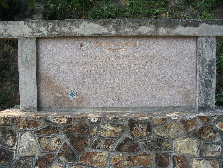
The Wilson Trail (Chinese: 衛奕信徑) is a 78 km long-distance footpath in Hong Kong, 63 km of which runs through Hong Kong country parks. It was named after David Wilson, Baron Wilson of Tillyorn, who was Governor of Hong Kong from 1987 to 1992. The Wilson Trail was developed by Friends of the Country Park and sponsored by various private organisations. The construction work of the trail began in 1994. The Wilson Trail was first opened on 21 January 1996.
Contents
- Hong kong hiking wilson trail section 9 9
- Wilson trail sections 1 2 up and over hong kong island
- Stages
- Stage 1
- Stage 2
- Stage 3
- Stage 4
- Stage 5
- Stage 6
- Stage 7
- Stage 8
- Stage 9
- Stage 10
- Wild monkeys
- Access points and facilities
- Start
- Between stages 1 and 2
- Between stages 2 and 3
- Between stages 3 and 4
- Between stages 4 and 5
- Between stages 5 and 6
- Between stages 6 and 7
- Between stages 7 and 8
- Within Stage 8
- Between stages 8 and 9
- Between stages 9 and 10
- Trail terminus
- Raleigh Challenge
- Other long distance trails of Hong Kong
- References
In all, the Wilson Trail traverses eight of the Country Parks. On Hong Kong Island, Tai Tam Country Park and its Quarry Bay Extension begin the journey. Across the harbour, there is a gap where the trail runs through hills outside the parks. Then come the three parks named Ma On Shan, Lion Rock, and Kam Shan. In the central New Territories, the Wilson Trail heads north through Shing Mun Country Park and Tai Mo Shan Country Park. Finally it climbs into the majestic Pat Sin Leng Country Park. Each of the Country Parks the Wilson Trail traverses has its individual character and appeal – offering, as one proceeds from south to north, changing settings with much of interest.
The trail is aligned north-south and runs from Stanley, in the south of Hong Kong Island to Nam Chung, in the northeastern New Territories. Of the four long-distance trails, the Wilson Trail is the newest. Since the trail crosses Victoria Harbour, it makes use of the MTR.
Wilson trail sections 1 2 up and over hong kong island
Stages
The Wilson Trail is divided into ten stages: and is marked by distance posts W001 – W138. Although the other major Hong Kong trails measure distance posts every 500m, the distances between posts on the Wilson Trail range from 500m – 650m.
Easy walk
Fairly difficult
Very difficult
Stage 1
The Wilson Trail makes a challenging start: Section 1 ascends straight up the sheer hillside of the double hill known as "The Twins", a favourite of local hikers. The stepped path ascends through low shrubs, flowering with pink melastoma in spring. On each side diagonal ridgelines cut the sky, and to the right there are mountain clefts. The scattered Stanley community spreads out below, and farther off the Stanley and D'Aguilar peninsulas frame distant Beaufort Island and rugged Poi Toi.
The climb is long and occasional pauses reveal ever more dramatic vistas. On still blue days the hillsides shimmer, on grey windy days they are exhilarating. The suggestion of a summit comes into sight, but instead one reaches a knoll with a view compass. Here there are fine vistas into Repulse Bay and Deep Water Bay, enclosed by the Chung Hom Kok headland. On the other side is a whaleback ridge, and beyond it steep plunging gullies. Beyond the expanse of Tai Tam Bay lie the Dragon's Back and Mount Collinson.
Stage 2
Making a steady climb along a spur, the Wilson Trail begins Section 2 through the eastern ranges. Higher up, amidst low shrubland, past old wind-bent pines, the path leads towards a summit. To the left there are glimpses of Wong Nai Chung Gap and the city – to the right the beautiful Tai Tam valley spreads out.
A kilometre up from Parkview the path reaches Jardine's Lookout (433 metres) – curiously exactly the same height as Violet Hill, now seen across the valley. The views from Jardine's Lookout are surely startling. To the left of the survey marker, one gazes down onto massed humanity in the urban districts. Yet, except perhaps on weekends, your only likely company here will be passing ants – or the kites wheeling overhead. Long descending ridges frame the city. On the other side lies raw nature: the Tai Tam valley, wooded and green, with its nestling reservoirs. Beyond there the rugged coast of Tai Tam Bay extends out, and still farther off rise some outlying islands.
Stage 3
A trifle mystified at how it crossed the harbour, the Wilson Trail makes up for any lapse as Section 3 twists energetically up Devil's Peak (222 metres). It unhappily joins sections of a couple of roads: O King Road and Ma Yau Tong Road. Past the remains of an old hilltop fort, the trail has fine panoramas – out across Tathong Channel to turtle-shaped Tung Lung Chau, over the harbour to its rim of buildings and mountains, and northeastwards to Clear Water Bay Peninsula.
Wayside cuttings and fern banks lead us on. Then, just through a small pass, one looks back to the impressive northern face of Devil's Peak with its sheer forbidding cliffs. So begins a section of hiking trail that only Hong Kong could offer, with startling contrasts of country and city. On one hand there are dark heavy boulders, reddish earth, bracken, bamboos – and the sounds of birdsong. On the other, just a few hundred metres away, a line of tower blocks forms a barrier – and the rumble of city traffic comes up.
Farther on a steep path ascends to Black Hill, past boulder outcrops veined with quartz. The flat-topped summit of Black Hill (304 metres) presents the first all-round view of Kowloon peninsula. The hill itself – steep, rocky, scrubby – drops down to a fringe of tower blocks, farthest sentinels of urban districts that reach back and back. Incredibly densely developed, Kowloon presents an awesome concrete expanse. How good to be up in the hills!
As the Black Hill ridge winds on new vistas open up. To the north and northeast are hints of the grandeur of Clear Water Bay Peninsula and the Sai Kung region. Ranges recede into the distance. And, on clear days, the profiles of Ma On Shan and Sharp Peak rise up – the former with its hollow saddle, the latter with its twisted conical summit.
Stage 4
Hillsides thick with trees line the Wilson Trail where Section 4 climbs up from Tseng Lan Shue. Utterly different to the open ridges of the previous section, here an old stone paved village path ascends into the hills. The air is moist, the ground carpeted with fallen leaves. Lichen covered trees and jumbled boulders line the trail. Farther up, deeper into the woods, the last sounds of the village fade. With no distant views to savour, close up details dominate. Bright green foliage shimmers with the wet. The only sounds are the buzz of insects, chirping birds and the drip-drip of ground water.
Beneath slender bamboos one comes upon a lovely spot – where a mountain stream gurgles down. Boulders stand green with moss, ferns hang from overgrown terrace walls. The same stream that once irrigated the nearby fields now feeds nature – and aquatic life, tiny fish and crustaceans that since ages have lived here dart through the waters.
Some distance on one reaches the village of Tai Lam Wu, where the long climb up to Tate's Pass begins. The route starts amidst woodland, lower and scrubbier than before. Lianas hang down, roots cross the path. Barbed pandanus fronds threaten to scar passing hikers' legs.
Stage 5
A short distance northwest of Sha Tin Pass, the Wilson Trail offers the first glimpse of the northern regions that it later crosses. Section 5 descends some gravelly hills. Here, along a bracken path, splendid vistas open up of the far northwest.
Pencil pines and thick stands of paperbarks, yellow-brown bark peeling, spread over the hills, while in the valley richer hues show native trees which have propagated naturally. Beard-like orange mosses and grey-green lichens edge the path. Dwarf bamboos and sedges hem in the small gully streams Swinging out along the path, an opposite ridge closes in the scene. Then, around a corner, the vistas suddenly open up. Sha Tin's tower blocks extend to the left beneath the foothills – and far off the ramparts of Pat Sin Leng rise up, 15 kilometres due north but over twice that distance as reached along the Wilson Trail.
Farther on, by a distinctive pine knoll, is a fine panorama of the southern New Territories. Sha Tin is now in central view, cradled between the Tai Mo Shan and Ma On Shan massifs. All the region's main summits are in sight: the great bulk of Tai Mo Shan, the sharp profile of Needle Hill, Grassy Hill's rounded summit – and, to the right, the magnificent uplands around Ma On Shan and The Hunch Backs.
Stage 6
Arrived at the first of the three reservoirs it passes close by, the Wilson Trail ascends above Kowloon Reservoir – where Section 6 heads northwest into the central New Territories. The woodland here is lower than the forests along the previous catchment trail, yet even so the reservoir soon disappears from sight behind trees. An earthen path, initially reasonably level and then steadily ascending, winds up behind the reservoir through Kam Shan valley. Fallen leaves lie soft underfoot, the banks are hung with plants and ferns. Lianas tangle through the middle storey of this maturing forest, the end result of earlier reforestation to stabilise the reservoir's watershed slopes.
Occasional panoramas open out showing the Kowloon peaks. Less often breaks in the trees reveal glimpses of the reservoir, with its ochre banks and jade green waters, typical of all the local dams. Come here in winter and the galley-prow banks will be high out of the water – but in summer, after rain, water laps right up to the trees. Hiking farther around one crosses a series of small gully streams that run into the reservoir. Sharp edged pandanus fronds, dwarf bamboos and ferns surround the small watercourses – hidden worlds where, in rock pools up and down the hillsides, crustaceans and tiny fish inhabit the often turbulent streams.
The best time to be here is the late afternoon after a fine, clear day. Then, the sun westering over Shing Mun, gaps between the trees show Kowloon Reservoir at its best. Mirror waters reach across to a turreted dam – the woodland shimmers with emerald greens – black-eared kites wheel overhead. As zephyrs fade, stillness gathers up the land.
Stage 7
Now just over halfway along the Wilson Trail's entire length, the route crosses Shing Mun dam and turns northwards – where Section 7 begins its journey along the reservoir. The valley setting is impressive and, off to the left, Tai Mo Shan's imposing slopes and summit rise up.
The trail leading around the eastern banks is one of the territory's most attractive reservoir walks. The water lies close below, the vegetation is varied – and, given the elongated inlets, the path's turns bring ever-changing vistas. At the start one is looking generally north, across the water to rising wooded slopes. The reservoir itself, edged with orange-brown banks, runs back into narrow inlets ending at stony gullies. Hiking farther on, larger inlets provide views to the south – to the main dam wall and in one place right back to Smuggler's Ridge. The hillside vegetation becomes richer towards the far end, with fern-filled depressions, canopy trees and – in one place – a curtain of overhanging bamboos. Gully streams enclose lush vegetation, with mosses and lichens.
So the reservoir leads around, with ever changing surroundings and fresh vistas. Towards the northern end its waters narrow. Here one gazes past lagoons to the western shore. Paperbark trees flourish on swampy land, helped by inundations when the reservoir over fills. In spring yellow-flowered acacias colour the hills. Beyond the narrow head of the reservoir a woodland trail wends uphill, amidst tall bamboos. At the top, a stream crosses the path – its shaded rock platform making a pleasant oasis for resting.
Farther on, the woodland is at its most mature and striking. In the densely vegetated gullies, amidst lichen boulders and moss banks, huge elephant ear plants and massed ferns luxuriate.
Stage 8
Drawn downhill into suburban surroundings, the Wilson Trail perhaps wishes that it could leap across Tai Po's developed areas – and begin Section 8 with the clear enticing challenge of climbing Cloudy Hill. Some hikers may wish to do exactly that. But, described below, we follow the mapped route, though hurrying across the first part.
Turning left uphill, past the Fan Sin Temple and gradually working up through villa homes, the route has earth paths, concrete steps, bitumen and later a narrow road. Initially climbing, then running along a level, it skirts the valley's middle slopes past grassy hillsides and nursery farms. After a two-kilometre excursion through here, the trail descends to Shek Kwu Lung. Then, across the river, it goes northwest for 400 metres – before taking a right turn, to head to Tai Po Tau Drive. This is the least attractive part of all the Wilson Trail, and you may prefer to go by taxi to Tai Po Tau Drive.
The trail up to Cloudy Hill is exhilarating. As it ascends, woodland quickly gives way to shrubland, blazing pink in spring with melastomas. Then, beyond the first pavilion, wide panoramas begin to appear.
Stage 9
Continuing down the northern slopes of Cloudy Hill, the Wilson Trail descends through attractive uplands. Section 9 looks across to still grander country, where the trail later winds up into the Pat Sin range and along its serrated ridgeline. Undulating heathland begins the descent. Gaps between the hills reveal the far north New Territories, with its narrow plains before the Shenzhen River. Ahead and to the right the magnificent bulk of Pat Sin Leng draws steadily closer.
Lower down, now close above the ox-bow waters of tiny Hok Tau Reservoir, is one of the most delightful settings in Hong Kong. Surrounded by slopes of pink flowering melastoma and other shrubs, armies of frogs croaking below, one overlooks a secluded valley. Farther off ridges recede into the background, each framing another still higher one – right back to Ma On Shan, some 12 kilometres distant.
Down at Hok Tau, the path skirts the reservoir with its fringe of lush growth. Then it leads up through a pine forest, before turning straight uphill to begin the ascent to Pat Sin Leng. Up and up – a rocky trail and stone steps push to the top. Pausing for breath the views are majestic. Pat Sin Leng sweeps up, slopes rising towards a cliff edge escarpment. Down in the valley a stream meanders through woodland.
Higher still the entire region reveals itself. Beyond an intervening saddle the villages of Sha Lo Tung appear, abandoned and overgrown. Across the farther ridgeline the tips of Tai Po's buildings come into view, with Ma On Shan rising across Tolo Channel. Beyond a ravine, wild and inhospitable, stand the Shenzhen skyscrapers – supremely surreal seen from here.
Stage 10
The eastern extremity of Pat Sin Leng marks the final turning along the Wilson Trail – where Section 10 swings northwest and descends to Nam Chung. Now over 70 km along the trail from its start at Stanley, though only 30 km due north of there, this is the Wilson Trail's culminating section.
The summit at Hsien Ku Fung, on three sides surrounded by sheer slopes, offers a bird's eye panorama of the far northeast – a barely inhabited region of striking beauty. Immediately to the east Plover Cove Reservoir spreads out, its 6 km expanse of water reaching back to rugged hills. Northeast is the tangled country that encloses Double Haven, with its islets and islands. Northwest, where the trail leads, hills descend to Nam Chung.
Down from the summit, panoramas extend across wooded hills to Wu Kau Tang – and over Starling Inlet to Sha Tau Kok. The trail continues on amidst shrubland and, farther down, enters low woodlands. After the windswept heights of Pat Sin Leng it seems lush.
Wild monkeys
There are significant numbers of monkeys along the trail in Stages 6, 7, and 8. They tend to be aggressive with regard to food. Do not carry loose shopping bags, etc., as they may be bold enough to attempt to grab them from you. Also, try to pack your garbage out of the parks: much of the garbage strewn around the picnic areas is the result of monkeys raiding rubbish bins. Visitors are reminded not to feed these wild animals as uncontrolled feeding has led to unnatural growth of the monkey population and caused nuisances. A feeding ban has been implemented and enforced in the area since July 1999 to help the monkeys revert to forage natural food in the natural environment.
These monkeys are mostly rhesus macaques (Macaca mulatta), although there also exist long-tailed macaques (Macaca fascicularis) and rhesus/long-tailed hybrids.
The original wild stock of rhesus macaques is believed to have become extirpated. The existing wild monkey populations are considered as the descendants of the individuals which have been introduced to the Kowloon Hills, i.e. Kam Shan and Lion Rock Country Parks in the 1910s. It is believed that the rhesus macaques have been re-introduced to Hong Kong to control the spread of a local poisonous plant, the strychnos. Because strychnos' fruit is toxic to humans, there was concern that they may contaminate the reservoir water. But strychnos is not poisonous to monkeys; on the contrary, it is one of their favourite foods. Long-tailed macaques were introduced to the parks in the 1950s.
Access points and facilities
All up-to-date bus route and schedule information can be found via the Hong Kong Transport Department website.
Start
Stage 1 begins on Stanley Gap Road. The 6, 6A, or the 260 buses from Stanley Market or Central, or the 73 bus from Stanley or Cyberport, stops on request at the trailhead. Buses are frequent in both directions. There are no facilities here.
There is no pedestrian access to the trail head from Stanley Market: the sidewalk ends around 200m after the bus stop and walking along the narrow, winding road in traffic is not recommended. Additionally, the promising footpath opposite the trailhead is a dead end, stopping at a locked gate after 100m-200m.
Between stages 1 and 2
Stage 1 ends/Stage 2 begins 100m from Hong Kong Parkview, where there is a ParknShop supermarket, bathroom facilities, taxi stand, and a shuttle bus (HK$20) to Wanchai and Central. Tickets for the bus can be purchased at the concierge desk inside the club, opposite the bus stop. Various public buses stop at the base of Tai Tam Reservoir Road on Wong Nai Chung Gap Road, 600m down the hill from the trail entrance.
Between stages 2 and 3
Stage 2 ends at Tai Koo Station MTR. There are a wide range of restaurants and convenience stores. There are bathroom facilities at Kornhill Plaza above the station. Stage 3 begins at Lam Tin Station MTR with a range of facilities.
Between stages 3 and 4
Stage 3 ends/Stage 4 begins at Clear Water Bay Road. There are a couple of small family-run convenience stores on the Stage 4 (north) side of the road. There are also several minibus stops to the west of the trail, including the 1A minibus that links to Choi Hung Station MTR stop.
Between stages 4 and 5
Stage 4 ends/Stage 5 begins at Shap Yi Wat Village. There may be a small shop available seasonally here. Shap Yi Wat Village is accessible by taxi (15 minutes from Wong Tai Sin MTR), but don't expect to find a taxi in the "village". The Sha Tin Pass Estate housing development is a 1.5K walk down Sha Tin Pass Road from the village and is serviced by the 18/18M green minibus. The 18/18M shuttles between Sha Tin Pass Estate and Wong Tai Sin Station MTR.
Between stages 5 and 6
Stage 5 ends/Stage 6 begins at Tai Po Road (Sha Tin Heights section) across from Kowloon Reservoir. There do not appear to be any usable facilities here, although the map indicate a public restroom 200m east along the road. The KMB buses 72 and 81 are available for easy access to various stations. The 81 toward Jordan (佐敦) stops at Mong Kok Station MTR.
Between stages 6 and 7
Stage 6 ends/Stage 7 begins at Shing Mun Reservoir (also known as the Jubilee Reservoir). There is no public transport access here, although a taxi can get within 50m. Don't expect to find a taxi waiting. Otherwise, it is a 1.6K walk to the 82 green minibus terminus on Shun Min Road. This bus will take you to Tsuen Wan Station. There is also a visitors center 50m from the bus terminus, but there are no facilities here.
Between stages 7 and 8
The 23S/23K green minibus travels between the residential village of San Uk Ka and Tai Po Market Station MTR. The stop is on the trail, 100m into Stage 8. The buses are frequent (at least every 15 minutes) and take around 10 minutes. Alternatively, the station is a 2K walk. There are two restaurants and a small grocery store opposite the drainage canal 100m past the trail turn at distance post 090.
Within Stage 8
Between distance post 97 and 98, the trail passes within 200m of a shopping center that connects to Tai Wo Station MTR. Follow the MTR sign posted on the trail on the north side of the drainage canal. There is a 7-Eleven and several restaurants at the shopping centre. This is the last place to resupply or access clean restrooms anywhere directly alongside the trail until the terminus (Stage 10) at Nam Chung.
Between stages 8 and 9
The transition from Stage 8 to Stage 9 is between distance post 105 and 106, near the peak of Cloudy Hill. Between distance post 107 and 108, there is a side trail/road that leads 2.8K to the small residential village of Kau Lung Hang, the terminus of the 25B green minibus. The road is steep, traversing more than 300m of vertical, so budget time accordingly. The 25B shuttles between Kau Lung Hang and Tai Wo Station MTR. There are no services at Kau Lung Hang.
Alternatively, one can enter/exit the trail at Hok Tau Reservoir. The 52B green minibus travels between Fanling Station MTR and Hok Tau Road. The bus terminus is around a 2K walk along Hok Tau Road and intersects the trail at the reservoir close to distance post 112. The last bus scheduled from Hok Tau Road departs around 8:30 pm.
Between stages 9 and 10
There is no convenient access. There is a steep trail from the Stage 9/10 switchover point atop Hsien Ku Fung down to Pat Sing Leng Nature Trail. The Pat Sin Leng Nature Trail starts at the Plover Cove Country Park Visitors Centre to the 20C green minibus stop. Total distance from the switchover to the bus stop is 1.1K. The 20C connects to Tai Po Market Station MTR.
Trail terminus
The trail terminus is at Nam Chung, on a side road around 1.5K from the main road. Confusingly, both the side road at the trail head and the main road are called "Luk Keng Road". The bus stop for the 56K green minibus shuttles between Luk Keng Village and Fanling Station MTR and will stop, on request, at the intersection of the main road and the side road. Those beginning the trail here can ask the bus driver to drop them at Nam Chung. For those returning from the trail, be warned that the last bus departs around 7:30 pm. Also, mobile phones are unlikely to work here (one is more likely to get a roaming signal from the mainland than a Hong Kong signal). An alternative return route is to walk 1 km east along the road toward Luk Keng Village—to the minibus terminus—and either take the bus, or if it is after 7:30 pm, ask someone at the small restaurant/convenience area to call a taxi for you.
There are bathroom facilities located around 500m from the trail terminus along the side road as well as at the intersection of the side road and the main road.
Raleigh Challenge
Raleigh International's "Raleigh Challenge – Wilson Trail" is the first hiking competition which covered the longest distance of the Wilson Trail, spanning across the Hong Kong Island, the Kowloon Peninsula and the New Territories from south to north. To avoid crowds at the trailhead on Stanley Gap Road, the Challenge bypasses the first 2K of Stage 1 ("The Twins") and instead takes a side trail to the lower part of Tai Tam Reservoir Road, passing Tai Tam Intermediate Reservoir and Tai Tam Tuk Reservoir, and heads to Tai Tam Road.
Other long-distance trails of Hong Kong
The Wilson Trail is the most recent of the four long-distance trails of Hong Kong. The others are: