
Opening date 1973 Owner Goulburn–Murray Water | Status Operational Height 35 m (115 ft) Inflow source King River Impound King River | |
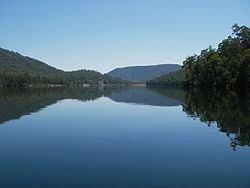 | ||
The William Hovell Dam is a rock and earth-fill embankment dam with a flip bucket chute spillway across the King River, located in the Hume region of Victoria, Australia. The purposes of the dam are for irrigation and the generation of hydroelectricity. The impounded reservoir is called Lake William Hovell
Contents
Map of Lake William Hovell, Cheshunt South VIC 3678, Australia
The dam and reservoir are named in honour of William Hovell, an explorer.
Location and features
The dam is located south of Whitfield on the edge of the Alpine National Park, fed by the King River and Evans Creek. It supplies water for approximately 24 square kilometres (9.3 sq mi) for irrigated crops, vineyards and grazing properties along the King River from Cheshunt to Wangaratta.
Completed in 1973 the rock and earth–fill dam structure is 35 metres (115 ft) high and 414 metres (1,358 ft) long. The 355-thousand-cubic-metre (12.5×10^6 cu ft) dam wall holds back the 13,500-megalitre (3.0×10^9 imp gal; 3.6×10^9 US gal) Lake William Hovell, when at full capacity, with a surface area of 113 hectares (280 acres). The unusual flip bucket controlled spillway has a discharge capacity of 2,195 cubic metres per second (77,500 cu ft/s). The dam is managed by Goulburn-Murray Water.
Outflow from the dam drives a 1.6 megawatts (2,100 hp) hydro-electric generator, with an average annual output of 3.7 gigawatt-hours (13 TJ), operated by Pacific Hydro.