
Population 1,331 Local time Sunday 6:14 PM | OS grid reference ST365655 Sovereign state United Kingdom Dialling code 01934 | |
 | ||
Weather 13°C, Wind W at 11 km/h, 59% Humidity | ||
Wick St. Lawrence is a civil parish and village in Somerset, England. It falls within the unitary authority of North Somerset. The population of the parish, which includes Bourton, in the 2011 census was 1,331.
Contents
Map of Wick St. Lawrence, UK
History
The parish of Wick St Lawrence was part of the Winterstoke Hundred, while Bourton was in Portbury Hundred.
The village lies near a small creek known as Slutspill near the River Yeo which was inundated in the Bristol Channel floods, 1607. The last wharf on the river was pier and spur of the old Weston, Clevedon and Portishead Railway (at what is known as "Tutshill Ear") which was torn up soon afterWorld War II]]. For a short period after this coal was imported from south Wales on its own 33 ton vessel the Lily, until it sank in a gale in 1929.
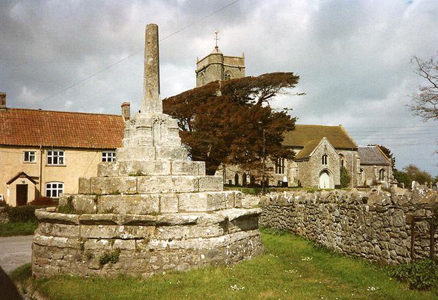
The 15th century village cross stands on an area of grass opposite the parish church, raised up on five ascending octagonal stone platforms. The crosshead was destroyed during the time of the English Civil Wars. It is a Grade II* listed building and Scheduled Ancient Monument.
The Ebdon Bow Bridge which carries the road from the village to nearby Worle over the River Banwell was built in the late 18th or early 19th century.
The parish has seen a vast increase in population in recent years, due to the building of the Ebdon Grounds housing development. This is an extension of the development of the neighbouring North Worle area, and the village itself remains separate from the new estate.
Governance
The parish council has responsibility for local issues, including setting an annual precept (local rate) to cover the council's operating costs and producing annual accounts for public scrutiny. The parish council evaluates local planning applications and works with the local police, district council officers, and neighbourhood watch groups on matters of crime, security, and traffic. The parish council's role also includes initiating projects for the maintenance and repair of parish facilities, such as the village hall or community centre, playing fields and playgrounds, as well as consulting with the district council on the maintenance, repair, and improvement of highways, drainage, footpaths, public transport, and street cleaning. Conservation matters (including trees and listed buildings) and environmental issues are also of interest to the council.
The parish falls within the ward of Kewstoke for the unitary authority of North Somerset which was created in 1996, as established by the Local Government Act 1992. It provides a single tier of local government with responsibility for almost all local government functions within their area including local planning and building control, local roads, council housing, environmental health, markets and fairs, refuse collection, recycling, cemeteries, crematoria, leisure services, parks, and tourism. They are also responsible for education, social services, libraries, main roads, public transport, Trading Standards, waste disposal and strategic planning, although fire, police and ambulance services are provided jointly with other authorities through the Avon Fire and Rescue Service, Avon and Somerset Constabulary and the Great Western Ambulance Service.
North Somerset's area covers part of the ceremonial county of Somerset but it is administered independently of the non-metropolitan county. Its administrative headquarters are in the town hall in Weston-super-Mare. Between 1 April 1974 and 1 April 1996, it was the Woodspring district of the county of Avon. Before 1974 that the parish was part of the Axbridge Rural District.
The parish is represented in the House of Commons of the Parliament of the United Kingdom as part of the Weston-super-Mare county constituency. It elects one Member of Parliament (MP) by the first past the post system of election. It is also part of the South West England constituency of the European Parliament which elects seven MEPs using the d'Hondt method of party-list proportional representation.
Geography
The village lies near the north west extremity of the North Somerset Levels approximately 1 kilometre (0.6 mi) inland from Woodspring Bay on the Bristol Channel coast and between the estuaries of the River Banwell and the Congresbury Yeo. The parish incorporates the two smaller hamlets of Icelton and Bourton and the Ebdon Grounds area of modern housing which is contiguous with neighbouring North Worle — itself a suburb of Weston-super-Mare.
The M5 motorway runs along the parish's south eastern boundary.
The majority of the parish is farmland — primarily livestock rearing — and comprises low-lying fields criss-crossed by hedgerows and rhynes or wide ditches.
To the north of the village between the mouths of the Banwell and Yeo is an area of reclaimed land known as Wick Warth. This land is a form of polder and lies between the current sea-wall and an older parallel high grass bank which runs for 1.5 kilometres (0.93 mi) between the estuaries. A similar area of reclaimed land continues on the northern bank of the Yeo in the neighbouring parish of Kingston Seymour. "Warth" is the local name given to such reclaimed polder land.
Religious sites
The parish Church of Saint Lawrence dates mainly from the 15th century. It is built largely of pink or grey Lias limestone combined with other local limestones and sandstones. These were used during a major restoration in 1864–1865 by Foster and Wood of Bristol, made necessary after the church was struck by lightning in 1791. This caused cracks to open in the tower which was then reinforced with iron bands. However over the next 60 years the church began to fall apart, prompting the restoration.
The window of the church are in the Perpendicular style, while the modest tower has a peal of six bells; the oldest of which were cast in 1655. The intricately carved stone pulpit came from Woodspring Priory in 1536 following the Dissolution of the Monasteries. The Priory had been bought by a Bristol Merchant, William Carr, and his son and heir John Carr (who subsequently became Lord to the Manors of both Congresbury and Wick St Lawrence) arranged the pulpit's relocation.
It has been designated as a Grade II* listed building.