
Local time Saturday 5:18 PM | ||
 | ||
Weather 11°C, Wind W at 11 km/h, 74% Humidity | ||
Wharram percy deserted medieval village
↦ Wharram Percy is a deserted medieval village (DMV) on the western edge of the chalk Wolds of North Yorkshire, England. It is about 1 mile (1.6 km) south of Wharram-le-Street and is signposted from the B1248 Beverley to Malton road. Wharram Percy was part of the East Riding of Yorkshire until the 1974 boundary changes.
Contents
Map of Wharram Percy, Malton, UK
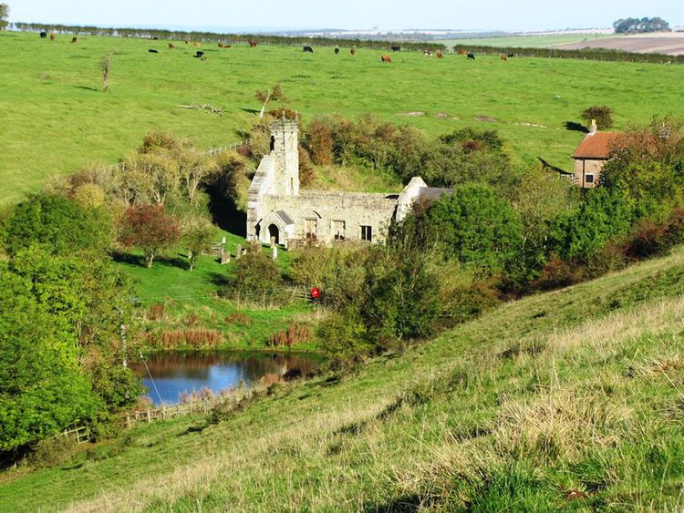
Wharram Percy is a significant English DMV, although there are remains of others in a similarly good state of preservation.
The earthworks of the village have been known for many years, and outlines of house platforms were drawn onto the first Ordnance Survey six-inch maps of Yorkshire published in 1854. The site was researched each summer by combined teams of archaeologists, historians and even botanists, from about 1950 to 1990 after it was singled out for study in 1948 by Professor Maurice Beresford of the University of Leeds.
History
Although the site seems to have been settled since prehistory, the village appears to have been most active from the 10th to the 12th centuries. The Domesday Book of 1086 records it as 'Warran' or 'Warron'. The suffix 'Percy' stems from the prominent, aristocratic family that owned the area during the Middle Ages.
The Black Death of 1348–49 does not seem to have played a significant part in the desertion of Wharram Percy, although the large fall in population in the country as a whole at that time must have encouraged relocation to larger settlements.
In 1402 or 1403, the Percy family exchanged their holdings in the area with the Hylton family. Following changes in prices and wages during the 15th century, pastoral farming (particularly sheep) was more profitable for landowners than cereal farming. Over the century following, the Hylton family devoted more and more land to sheep, as their employment of agricultural labour decreased. During the early 16th century, the last residents of Wharram Percy were evicted and their homes were demolished to make room for more sheep pasture.
Present site
The site is now in the care of Historic England. Although only the ruined church is easily visible above ground, much more of the village layout can be seen in the surrounding fields. English Heritage installed information panels around the site, and provided an audio tour downloadable in mp3 format from the English Heritage website.
A scientific study published in 2004 of human skeletal remains from the deserted village reveals details of disease, diet and death in a rural medieval community.
The Yorkshire Wolds Way National Trail passes through the site, and the Centenary Way long-distance footpath passes to the east of the village.