
Population 459 (2011) Sovereign state United Kingdom Local time Friday 10:30 PM UK parliament constituency Somerton and Frome | OS grid reference ST578249 Dialling code 01935 | |
 | ||
Weather 11°C, Wind SE at 14 km/h, 85% Humidity | ||
West Camel is a village and civil parish in south Somerset, England, about 7 miles (11.3 km) north of the town of Yeovil. Situated either side of the River Cam it lies just south of the A303 and has a population of 459. The parish includes the hamlet of Urgashay.
Contents
Map of West Camel, Yeovil, UK
Neighbouring villages include Queen Camel, and Bridgehampton.
History
The name "Camel" derives not from the animal but from the word "cantmeel" (or 'Cantmell' or 'Cantmel'), by which name West Camel was formerly known. "Cantmeel" itself derives from the words cant (ridge) and mael (bare). It has also been known as Camel Abbatis because of its association with Muchelney Abbey.
It is one of many sites in England identified as a possible setting of The Strife of Camlann, the final battle of King Arthur.
The earliest evidence of a settlement on the site dates to the tenth century in the form of the remains of a Saxon preaching cross dated to before 940 AD. The parish of West Camel was part of the hundred of Somerton.
The earliest written reference is dated 995 AD and takes the form of a grant by Aethelred II of the village to the monks of Muchelney Abbey. A 15th century tithe barn held produce for the grange of Muchelney Abbey.
100 m and 250 m north of Downhead Manor Farm are earthworks showing the site of houses, possibly including a manor house, tracks and a fish pond. The settlement existed before the Norman conquest and was abandoned by the late 18th century.
The Leland Trail runs through the village. The Leland Trail is a 28 miles (45.1 km) footpath which follows in the footsteps of John Leland as he traversed South Somerset between 1535 and 1543 in the course of his investigation of the region's antiquities. The Leland Trail begins at King Alfred's Tower on the Wiltshire/Somerset border and finishes at Ham Hill Country Park.
Governance
The parish council has responsibility for local issues, including setting an annual precept (local rate) to cover the council’s operating costs and producing annual accounts for public scrutiny. The parish council evaluates local planning applications and works with the local police, district council officers, and neighbourhood watch groups on matters of crime, security, and traffic. The parish council's role also includes initiating projects for the maintenance and repair of parish facilities, as well as consulting with the district council on the maintenance, repair, and improvement of highways, drainage, footpaths, public transport, and street cleaning. Conservation matters (including trees and listed buildings) and environmental issues are also the responsibility of the council.
The village falls within the Non-metropolitan district of South Somerset, which was formed on 1 April 1974 under the Local Government Act 1972, having previously been part of Yeovil Rural District. The district council is responsible for local planning and building control, local roads, council housing, environmental health, markets and fairs, refuse collection and recycling, cemeteries and crematoria, leisure services, parks, and tourism. West Camel is part of the electoral ward of Camelot.
Somerset County Council is responsible for running the largest and most expensive local services such as education, social services, libraries, main roads, public transport, policing and fire services, trading standards, waste disposal and strategic planning.
It is also part of the Somerton and Frome county constituency represented in the House of Commons of the Parliament of the United Kingdom. It elects one Member of Parliament (MP) by the first past the post system of election, and part of the South West England constituency of the European Parliament which elects seven MEPs using the d'Hondt method of party-list proportional representation.
Religious sites
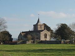
The Church of All Saints dates from the late 14th century and has been designated as a Grade I listed building.
The rectory dates from the early 15th century. The older wing may form part of the Grange pertaining to Muchelney Abbey; the South wing was probably added by Revd. Henry Law between 1824 and 1836.