
Surface elevation 149 m | Basin countries United States Catchment area 51.8 km² | |
 | ||
Primary inflows | ||
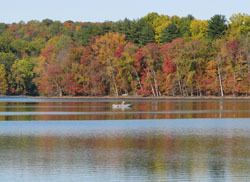
The West Branch Reservoir, formed by impounding about one quarter of the West Branch of the Croton River, is located in Putnam County, New York, United States, in the towns of Kent, New York, and Carmel, New York, and is only about 45 miles (72 km) north of New York City's Central Park Reservoir.
Map of West Branch Reservoir, New York 10512, USA
The West Branch is the second northernmost reservoir in the Croton Watershed, and is one of 12 reservoirs in the watershed. Its drainage basin is about 20 square miles (32 km²), and it can hold up to 8 billion US gallons (30,000,000 m3) of water at full capacity. The West Branch consists of two basins, separated by State Route 301. It was put into service in 1895 as part of New York City's Croton Water Supply System.
The West Branch now functions primarily as part of the Delaware Water Supply System, serving as a supplementary settling basin for the water which arrives from the Rondout Reservoir, west of the Hudson River, via the Delaware Aqueduct. The West Branch Reservoir also receives water from its own small watershed and the Boyds Corner Reservoir. In addition, the West Branch is connected to adjacent Lake Gleneida, one of the three controlled lakes that are part of the City's water supply.
Another function of the West Branch Reservoir is to receive water pumped in from the Hudson River during drought periods. This water enters the West Branch from the City's Chelsea Pumping Station in Dutchess County, 65 miles (105 km) up the Hudson from New York City. The West Branch was used very briefly for this purpose during May 1989 and during the 1965–66 and 1985 droughts.
Water withdrawn from the West Branch ordinarily flows via the Delaware Aqueduct, through the Croton Falls Reservoir and the Muscoot Reservoir, before stopping at the Kensico Reservoir in Westchester County for further settling. There it mixes with Catskill system water before entering aqueducts that carry it to the Hillview Reservoir in Yonkers, at the City's northern boundary, where it enters the water supply distribution system. It would continue through the rest of the city, flowing through the boroughs of The Bronx, Queens, and Brooklyn. The water finally stops at Staten Island.
Though the West Branch Reservoir is located within the Croton watershed, it is classified as part of the Catskill / Delaware System — and not the Croton System — by the New York City Department of Environmental Protection, which controls and manages all of New York City's reservoirs.