
Trailheads Main RoadFolly Road Length 8.8 mi (14.2 km) | Season Year round Trail difficulty Easy | |
 | ||
Use Cycling, Walking, Hiking, Jogging | ||
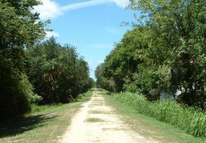
West ashley greenway bike path in charleston sc
The West Ashley Greenway is a rail trail in Charleston, South Carolina. It stretches across the West Ashley neighborhood from Main Rd in the west to Folly Road in the east. It is a straight and mostly unpaved path utilized for walking, jogging, and off-street cycling. The distance of the main trail currently covers 8.8 miles (14.2 km). It is a contributing segment of the East Coast Greenway.
Contents
- West ashley greenway bike path in charleston sc
- Map of W Ashley Greenway Charleston SC USA
- West ashley greenway riffle s helmet cam wapoo to maybank john s charleston sc
- References
Map of W Ashley Greenway, Charleston, SC, USA
The former railway was abandoned in 1981 and over time, the City of Charleston entered into leasing agreements with utility companies that took over the right-of-way to allow for public access. The last section of the trail was completed in 2007.
West ashley greenway riffle s helmet cam wapoo to maybank john s charleston sc
References
West Ashley Greenway Wikipedia(Text) CC BY-SA