
Native name Weißeritztalbahn Maximum incline 3.47% Track gauge 750 mm (2 ft 5 1⁄2 in) | Minimum radius 50 m (160 ft) Route number 513 Line number 6966 Line length 26.335 km (16.364 mi) | |
 | ||
Operating speed | ||
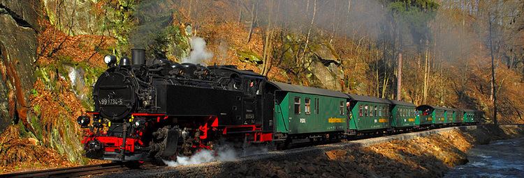
Weisseritz valley railway september 2014
The Weißeritz Valley Railway (German: Weißeritztalbahn) is a steam operated narrow gauge railway in Saxony, Germany. The line connects Freital, near Dresden, with the spa of Kipsdorf in the Ore Mountains, and follows the valley of the Red Weißeritz. It was badly damaged by major flooding in 2002 and is only partially operational, with fully restoration expected in 2016.
Contents
- Weisseritz valley railway september 2014
- History
- Damage in 2002 floods
- Technical specification
- The route
- References
The line was the second Saxon narrow gauge railway to be built, and is also considered to be the oldest public narrow gauge railway in Germany still in operation.
Since 14 September 2004, the line has been operated by Saxon Steam Railway Company (formerly the BVO Bahn), a company that also operates the Fichtelberg Railway and Lößnitzgrund Railway.
History
The construction started in 1881. The gauge selected for the line was 750 mm (2 ft 5 1⁄2 in), in common with other Saxon narrow gauge railways. The first section to Schmiedeberg was put into operation on 1 November 1882. On 3 September 1883, the regular trains reached the terminal station at Kurort Kipsdorf.
In 1912 a part of the track was relocated to allow construction of the Malter Valley Dam. In 1920 construction began on the Pöbel Valley Railway (Pöbeltalbahn) that was to link Schmiedelberg, on the Weißeritz Valley Railway, to Moldava, now in the Czech Republic. This line was expected to bring additional freight traffic, but construction was abandoned in 1923 and never resumed.
Freight traffic ceased on the line in 1993, leaving only passenger traffic. By the time of the floods in 2002, the railway carried approximately 200,000 passengers per year.
Damage in 2002 floods
The railway was badly hit by the major flooding in 2002, which severely damaged most of the track and infrastructure. This damage mirrored that of 1897, when almost all the line's bridges were damaged or destroyed.
The damage was estimated to be around €20 million and a fund-raising campaign was organised. The Federal government and the Government of Saxony agreed to cover one half of what is needed to rebuild the railway line. The section of line between Freital-Hainsberg station and Dippoldiswalde, the normal passing point for trains, was reopened on 14 December 2008. Six return trains per day are normally operated on this section.
The section of line from Dippoldiswalde to the terminus at Kurort Kipsdorf was due to reopen in 2010, however reconstruction has now been halted whilst the cost of rebuilding the first section to reopen is investigated. The rebuilding was originally expected to cost €19 million, but to date has cost €22.5 million. As this has coincided with budgetary cutbacks for the Saxon narrow gauge lines, new sources of funding need to be found if the rebuild is to be completed.
Technical specification
The route
The track begins at Freital-Hainsberg station on the standard gauge railway from Dresden to Chemnitz, and at an altitude of 184 m (604 ft).
The other stations and stops are as follows: