
Length 36 km | Basin size 161.2 km (62.2 sq mi) Basin area 161.2 km² | |
 | ||
Main source Eastern Ore Mountains787 m (2,582 ft) | ||
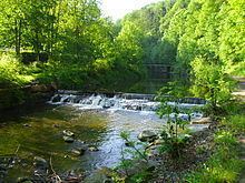
The Red Weißeritz (German: Rote Weißeritz) is a river in Saxony that drains the eastern Ore Mountains. It is a right tributary of the Weißeritz and is 36.5 km long. The source of the river is near Altenberg at a height of about 787 metres.
Map of Rote Wei%C3%9Feritz, Germany
The river drops through a height of 606 metres as it heads north-west, running through Schmiedeberg, the district town of Dippoldiswalde and ending in Freital where it forms the Weißeritz together with the longer tributary of the Wild Weißeritz. The Malter reservoir was built between 1908 and 1913 between Dippoldiswalde and Freital for flood protection reasons after the 1897 floods.
The deep valley is an important transport route. It is an historic approach to a major mountain pass over the Ore Mountains (the Graupen Pass). The Weisseritz railway runs through the Weißeritz valley up to the spa town of Kipsdorf, climbing about 350 metres in height. The B 170 federal road follows the river bank between Dippoldiswalde and Bärenfels where it leaves the valley, climbing through three hairpin turns.
The Red Weißeritz caused massive destruction during the 2002 European floods. Housing and especially road infrastructure was destroyed or damaged over a wide area. The flood retention basin of the Malter Reservoir completely overflowed. The area around the source of the river received precipitation of up to 312 mm in 24 hours.